
Iceland Volcano: Slow Decrease In Lava Flow From The Eruption -- Iceland Met Office
Categories
Edited | All Content | Disasters | Earthquakes | Volcanos | Government | Science | Europe | Atlantic Ocean | News | News -- WNT Selected
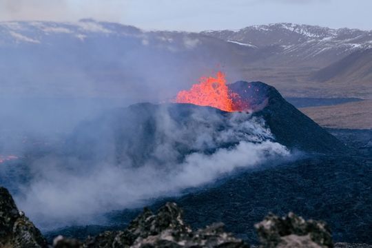 Volcano eruption at Sundhnúkur. Photo taken 10 April 2024 by Jón Bjarni Friðriksson/IMO.
Ground deformation continues, with a steady inflow of magma beneath Svartsengi. Unchanged hazard assessment
Updated 9. April at 17:30 UTC
Despite a decrease in the intensity of the volcanic eruption, there are no signs that the overall magma flow from the depth is decreasing.
The average flow rate of the lava flow from the vents between April 3rd and 8th is estimated to be 3.6 ± 0.7 m3/s.
Periodically high levels of SO2 continue to be measured around the volcano and in settlements on the Reykjanes Peninsula. Residents are advised to monitor air quality in the area.
Experts from the Icelandic Meteorological Office and the National Land Survey conducted aerial measurements over the eruption site April 8. Using the data collected during the flight, it is possible to assess the size of the lava field and the flow rate of lava from the eruption. The results indicate a steady and substantial decrease in the intensity of the volcanic eruption.
The average lava flow from the vents between April 3 and 8 is estimated to be 3.6 ± 0.7 m3/s. Based on data collected by the engineering firm Efla on April 3 during a drone flight, the average lava flow was estimated to be 6.6 ± 0.3 m3/s from March 27 to April 3. The lava field has reached an area of 6.14 km2 with a volume of 31.3 million m3. Previously, the lava primarily flowed south from the vents but briefly shifted northward on Sunday evening (April 7) when a vent wall collapsed, as mentioned in the last update. As shown on the accompanying map, the lava has thickened significantly near the vents and just south of them, where the most activity is in the lava field. There are no apparent signs of lava advancement toward protective barriers north of Grindavík, Suðurstrandarvegur, or Melhólsnáma.
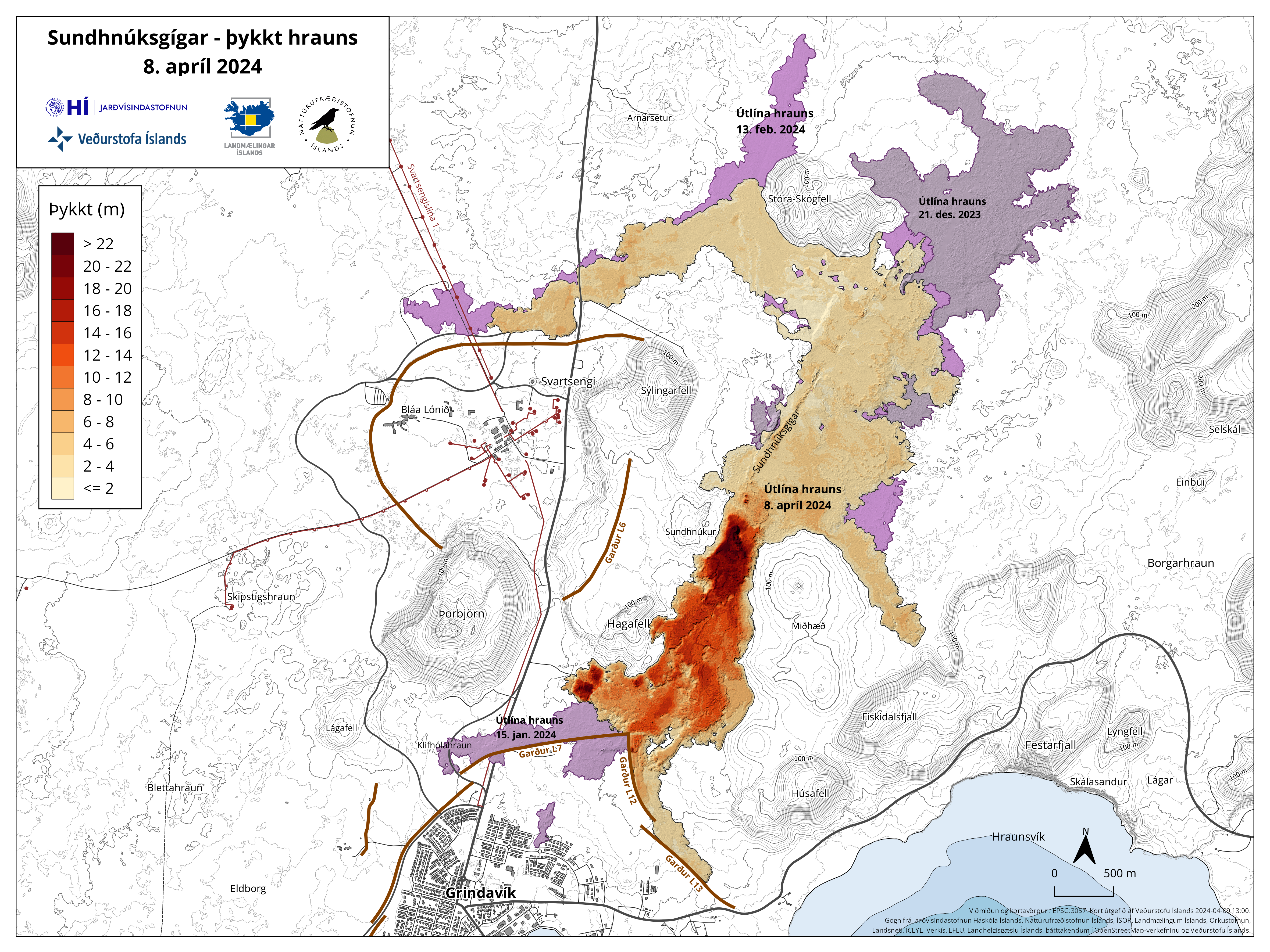 Map showing the extent and thickness of the lava formed in the current eruption. Purple areas show lava that has flowed in the area since December 2023. Click to enlarge.
Ground deformation has increased over the past week
Ground deformation in Svartsengi continues to increase, coinciding with a decrease in the intensity of the volcanic eruption. This indicates that the majority of the magma flowing into the reservoir beneath Svartsengi is accumulating there, causing an increase in pressure and ground uplift. While the eruption continues, there remains an open connection between the magma accumulation area in Svartsengi and the Sundhnúkur crater row, and a portion of the magma continues to flow to the surface there.
Seismic activity in the dike near Grindavík has remained very low and is focused between Sýlingarfell and Stóra-Skógafell, with slight seismicity in western Grindavík. Seismic activity near Fagradalsfjall, which has been persistent for the past month, is ongoing and remains localized at depths of about 6-7 km.
Gas measurements conducted April 8 estimate a sulfur dioxide (SO2) emission rate of 10-18 kg/s from the vents. Periodically high levels of SO2 continue to be measured around the volcano and in settlements on the Reykjanes Peninsula. Gas emissions from the eruption will likely cause pollution on the Reykjanes Peninsula, and residents are advised to monitor air quality and familiarize themselves with symptoms related to air pollution from the eruption.
According to the weather forecast, northerly winds are expected today, carrying gas emissions southward. Slow variable winds in the afternoon may result in gas pollution near the eruption sites. Easterly and southeasterly winds are expected tomorrow, carrying gas emissions westward and northwestward. Follow the gas dispersion forecast here.
Unchanged risk assessment
The hazard assessment has been updated and is valid until April 16th unless the situation changes. There are no changes in the hazard assessment, and the risk of gas pollution remains high in all areas except around the Sundhnúkur crater row (Zone 3), where it is assessed to be very high. The risk in Zone 4 (Grindavík) and Zone 6 remains high due to earthquakes, ground deformation, lava flows, and gas pollution.
 (Click on the image to see it larger)
Despite the decrease in the intensity of the volcanic eruption, there are no signs that the overall magma flow from depth into the Svartsengi reservoir is decreasing. This refers to the total volume of magma accumulating under Svartsengi, in addition to the magma flowing towards the surface in the current eruption at the Sundhnúkur crater row. It is difficult to predict when this eruption will end; it could continue for a longer period with steady flow or cease in the near future. As magma continues to accumulate under Svartsengi and pressure rises, a possibility remains that the eruption's intensity may increase again, similar to the events at Fagradalsfjall in 2021. If the eruption ceases soon, magma accumulation will likely continue under Svartsengi, and a sequence of events similar to that observed in the past month may repeat.
Updated 8. April at 16:30 UTC
- The volcanic eruption continues. One vent is active.
- The land has risen in Svartsengi approximately 2-3 cm between April 2nd and 7th.
- Minimal gas emissions were measured over the weekend, but periodically high levels of sulfur dioxide can still be detected around the volcano and in settlements on the Reykjanes Peninsula. Residents are advised to monitor air quality in the area.
- Today's weather forecast indicates a northeasterly wind direction, causing gas emissions to drift southwestward over areas including Grindavík. Easterly winds are expected tomorrow, April 9th, and gas emissions are anticipated to travel west from the eruption sites. Follow the gas dispersion forecast here.
The eruption at the Sundhnúkur crater row continues, with one vent now active. Yesterday, lava from the vent flowed southward in a constrained stream, resulting in a magnificent river of lava. Meanwhile, the surface level of lava in the crater gradually increased until it was nearly filled. The northern wall of the vent collapsed around 21:30 yesterday evening, causing the lava to flow northward. Today, April 8th, the lava flow has mostly resumed its southward direction. The lava advancing towards the north, as observed yesterday evening and overnight, appears to have halted on the hillside. The crater continues to fill up.
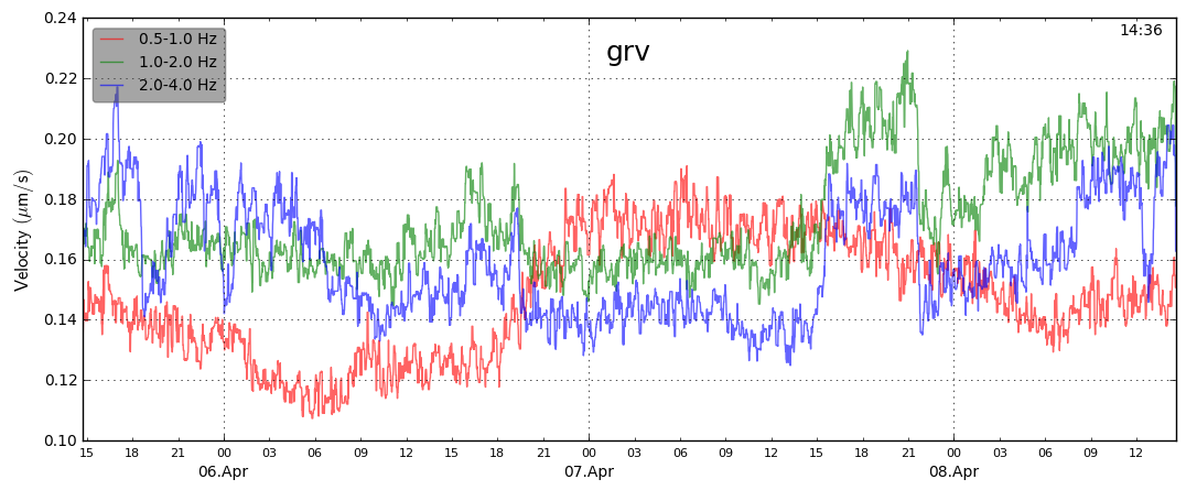
Seismic measurements near the eruption site show volcanic tremor that exhibits strong frequencies between 1 and 2 Hz (green curve on the graph); an increase in the strength of this tremor corresponds with the peak flow of lava from the vent. After the collapse of the vent wall, seismic activity appears to decrease again. Similar seismic activity was observed during the recent Geldingadalur volcanic eruption, during which seismic activity increased as the output of lava intensified.
Uplift has slightly increased in Svartsengi, and based on GPS measurements and synthetic aperture radar images, the land has risen by 2-3 cm from April 2nd to 7th. However, this is less than the ground deformation measured after the previous eruption last month. Increased uplift could indicate that magma flowing into Svartsengi has increased or that there has been a slowdown in the flow of magma towards the current eruption site.
Minimal gas emissions have been detected on gas monitors operated by the Environment Agency of Iceland (UST) and the Icelandic Meteorological Office over the weekend, but periodically high levels of sulfur dioxide can still be detected around the volcano and in settlements on the Reykjanes Peninsula. Residents are reminded to monitor air quality on the UST air quality website loftgæði.is
Today's weather forecast indicates a northeasterly wind direction, causing gas emissions to drift southwestward over areas including Grindavík. Easterly winds are expected tomorrow, April 9th, so gas emissions can be anticipated to drift west from the eruption sites. The latest gas dispersion forecast can be followed here.
- CreatedTuesday, April 09, 2024
- Last modifiedWednesday, April 17, 2024
World Desk Activities

cpj.org/resources-for-journalists-covering-protest…

cpj.org/2020/09/guide-to-legal-rights-in-the-u-s/

pressfreedomtracker.us/submit-incident/

drive.google.com/file/d/17XyVCVOTq59bvTEG_RZAQMgrF…

www.icfj.org/news/new-icfj-knight-fellows-work-sup…

U.S.Justice Department: "Radical Right vs. Radical Left: Terrorist Theory and Threat"
www.ojp.gov/ncjrs/virtual-library/abstracts/radica….
ijnet.org/en/story/tips-building-networks-reach-au…

trustingnews.org/how-trustworthy-is-your-newsroom-…

Latest Stories


Electronic Frontier Foundation
- The FBI is Playing Politics with Your Privacy May 10, 2024
- No Country Should be Making Speech Rules for the World May 09, 2024
- Free Speech Around the World | EFFector 36.6 May 08, 2024
- What Can Go Wrong When Police Use AI to Write Reports? May 08, 2024
The Intercept
- Israel “Likely” Used U.S.-Supplied Weapons in Violation of International Law. That’s OK, Though, State Department Says. May 10, 2024
- October 7 Survivors Sue Campus Protesters, Say Students Are “Hamas’s Propaganda Division” May 10, 2024
- AIPAC and Republican Donors Raising Big Money for Maxine Dexter Against Susheela Jayapal in Oregon May 10, 2024
- Even Biden’s Lawyers Are Urging the White House to Change Course on Gaza May 10, 2024
VTDigger
- Vermont Legislature adjourns after a contentious 2024 session May 11, 2024
- Vermont lawmakers reach late-night property tax deal, but bill looks destined for a veto May 11, 2024
- At the 11th hour, lawmakers strike compromise on Act 250 reform May 11, 2024
- Police identify family members killed Thursday in South Hero May 10, 2024
