Iceland Volcano: Uplift At Svartsengi Continues -- Iceland Met Office
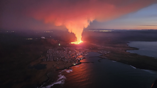 Lava flows from a fissure near Grindavik, Iceland, on Jan. 14, 2024. Iceland Department of Civil Protection
Magma is most likely no longer flowing into the dyke that formed on Jan. 14 suggesting that the eruption has ended. An updated hazard assessment still estimates that the danger of fissures within Grindavík is high.
Information is updated regularly here and on X (Formerly known as Twitter).
Updated 19 January 16:30 UTC
Clear signals of a continued land uplift are still being detected beneath Svartsengi. It is yet too early to assert whether the rate of the land uplift has increased since before the eruption on Jan. 14. First measurements suggest that is the case, but as has previously been written measurements can fluctuate from one day to the next and a longer timeline of measurement is needed to be able to interpret the long-term development of the land uplift.
Seismic activity continues to decrease in the area of the magma dyke and deformation signals seen on GPS devices suggest a significant slowdown of ground movement compared to previous days. This information suggests that magma is no longer flowing into the dyke and the eruption has ended.
GPS measurements also show small deformation within Grindavík. There is still a high danger of ground collapse into fissures within the town and thus important to map new fissures and changes to known ones estimated.
The Icelandic Meteorological Office has updated the hazard assessment due to the volcanic and seismic activity. The hazard level has been decreased in all zones.
An overall hazard assessment for zone 1, Svartsengi, is now down to yellow (moderate hazard).
An overall hazard assessment for zone 4, Grindavík, is now down to red (high hazard). Note that the colour of zones represents the overall hazard within those zones. A hazard that is rated greater within a zone is written in bold letters in the list of hazards on the map.
The hazard assessmept map takes effect at 15:00 Friday, Jan. 19, and is valid until Thursday, Jan. 25, at 15:00, unless there are significant developments.

- CreatedSaturday, January 20, 2024
- Last modifiedMonday, February 05, 2024
