
Iceland Volcano: Stable Eruptive Activity -- Iceland Met Office
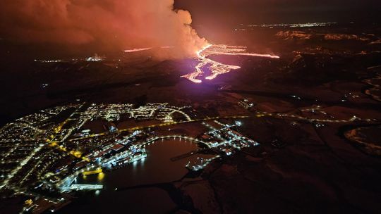 The eruption seen from the Coast Guard's surveillance flight with Grindavík in the foreground. The picture was taken at 00:15, March 17. (Photo: Public Safety/Björn Oddsson)
Lava flows south from the craters in an active stream
Updated 21. March at 11:40 UTC
Average discharge rate for 17 – 20 March is 14.5 m3/s
The new lava now covers an area of 5.58 km2 and has a volume of 20.9 million cubic meters.
Accumulation of magma below Svartsengi seems to have stopped and instead, magma flows directly to the surface and feeds the eruption.
Minor deformation has been measured in the Svartsengi area and in the proximity of the dyke intrusion.
The eruptive activity appears to have been relatively stable the last 24 hours. The same vents seem to be active, and craters continue to build up around the vents. Lava flows towards the south from the craters in an active lava stream, both on the surface and below the solidified surface of the lava.
 Overview of the eruption site taken on a flight yesterday morning 20 March at 9 a.m. It shows all the active volcanic vents. (Click to enlarge)
Yesterday morning experts from the National Land Survey of Iceland and the Institute of Natural History conducted aerial photography flights over the eruption site. From these images it is estimated that over the period from 17-20 March the average discharge rate of the eruption is 14.5 m3/s. This is a similar discharge rate as observed during the eruptions in Fagradalsfjall 2021-2023. However, the discharge rate during the first 24 hours of the eruption was significantly higher. The area of the new lava field was measured at 5.58 km2 and the volume was 20.9 million cubic meters. The map below shows the extent and thickness of the new lava as measured yesterday morning, 20 March. The lava is 16 m thick where it is thickest by the craters.
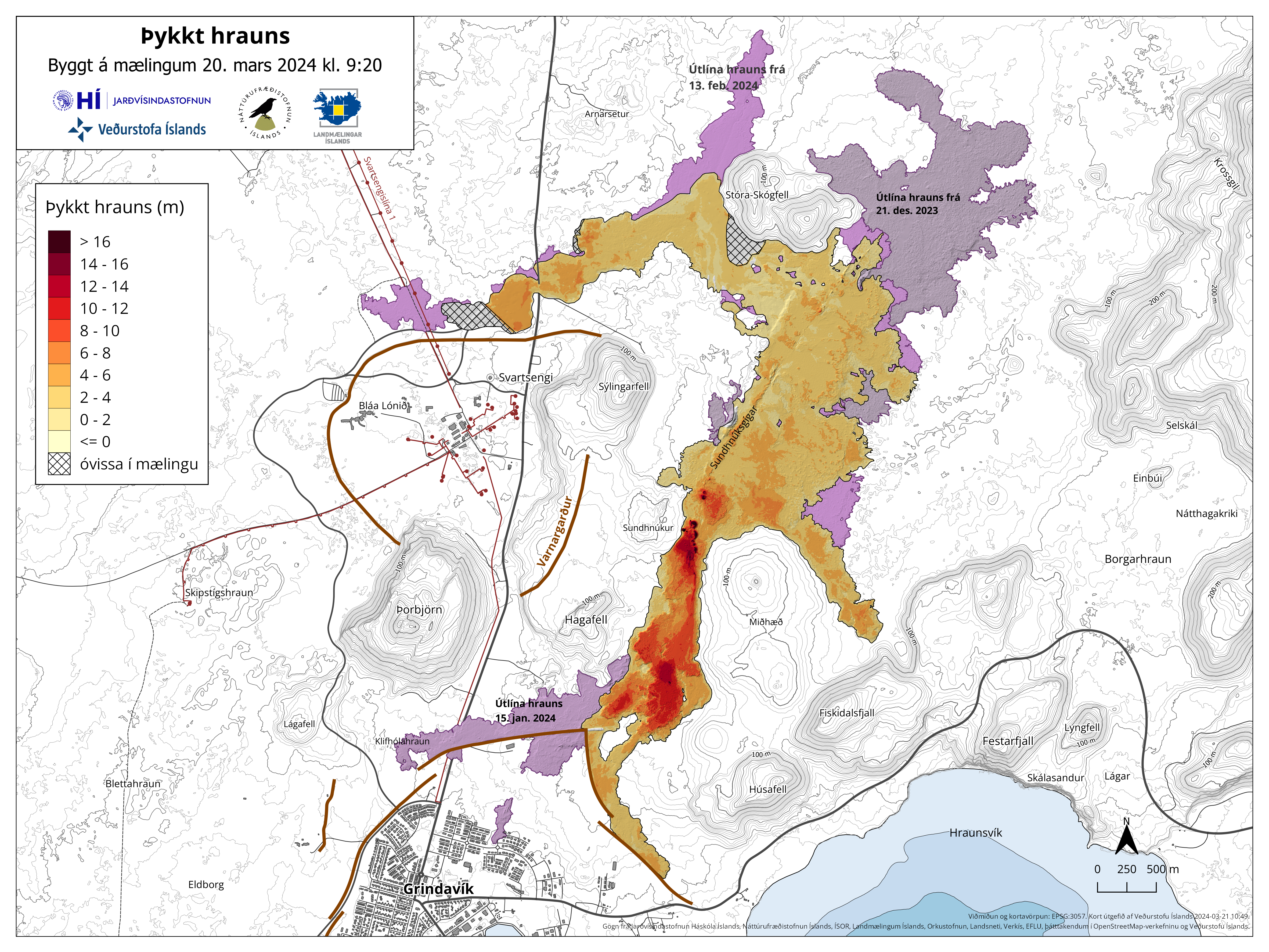 Map showing the extent of the newly erupted lava. Violet layers show the older lava that erupted in December 2023, January 2024 and February 2024. (Click to enlarge)
Very little deformation has been measured in the Svartsengi area and in proximity of the dyke formation. Any measured deformation is so small that variability between days is inconsiderable. Several more data points are needed to infer if any uplift continues in the area. Magma is flowing now directly to the surface, feeding the eruption.
The weather forecast today for the area is north and north-westerly winds, 8-15 m/s, gas pollution is dispersed to the east and south-east and could be felt in South Iceland, for example in Þorlákshöfn and in Vestmannaeyjar. A more northerly wind tomorrow (Friday), causing gas pollution to be dispersed to the south and south-east and could be felt in and around Grindavík.
- CategoriesEdited | All Content | Disasters | Earthquakes | Volcanos | Government | Science | Europe | Atlantic Ocean | News | News -- WNT Original
- CreatedFriday, March 22, 2024
- Last modifiedSaturday, March 23, 2024
SUBSCRIBE
Sign up for our weekly newsletter and World News Trust project updates.

World Desk Activities

www.imf.org/en/News/Podcasts/All-Podcasts/2024/05/…
en.vedur.is/about-imo/news/volcanic-unrest-grindav…

www.sciencealert.com/shift-in-indias-vulture-popul…
Shift in India's Vulture Population Linked to Half a Million Human Deaths : ScienceAlert
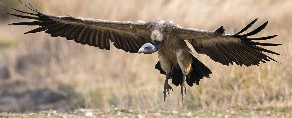
A cattle painkiller introduced in the 1990s led to the unexpected crash of India's vulture populations, which still haven't recovered to their former glory.

Tad author feed item to community feed
Latest Stories


Electronic Frontier Foundation
- Digital Apartheid in Gaza: Unjust Content Moderation at the Request of Israel’s Cyber Unit July 26, 2024
- Electronic Frontier Foundation to Present Annual EFF Awards to Carolina Botero, Connecting Humanity, and 404 Media July 25, 2024
- Briefing: Negotiating States Must Address Human Rights Risks in the Proposed UN Surveillance Treaty July 24, 2024
- Journalists Sue Massachusetts TV Corporation Over Bogus YouTube Takedown Demands July 24, 2024
The Conversation
- Vale Ray Lawler: the playwright who changed the sound of Australian theatre
- Magnificent and humbling: the Paris opening ceremony was a tribute to witnessing superhuman feats of the extraordinary
- How collaboration from across Canada, and the world, is helping fight the Alberta wildfires
- Paris Olympics: Canada’s soccer drone scandal highlights the need for ethics education
The Intercept
- Honduras, 15 Years After the Coup: An Interview With Ousted President Manuel Zelaya July 26, 2024
- Google Planned to Sponsor IDF Conference That Now Denies Google Was Sponsor July 25, 2024
- Deputy Accused of Killing Sonya Massey Was Discharged From Army for Serious Misconduct July 25, 2024
- U.S. Has Never Apologized to Somali Drone Strike Victims — Even When It Admitted to Killing Civilians July 25, 2024
VTDigger
- Waterbury residents looked to FEMA buyouts after last year’s floods. They’ve heard nothing for months July 26, 2024
- At a quiet Craftsbury pond, rowers become Olympians July 26, 2024
- UVM Medical Center wins approval to buy Fanny Allen Campus July 26, 2024
- Landslides and slurries have damaged homes, roads and driveways after this month’s flood July 26, 2024
