
Iceland Volcano: Ground Uplift Around Svartsengi Continues -- Iceland Met Office
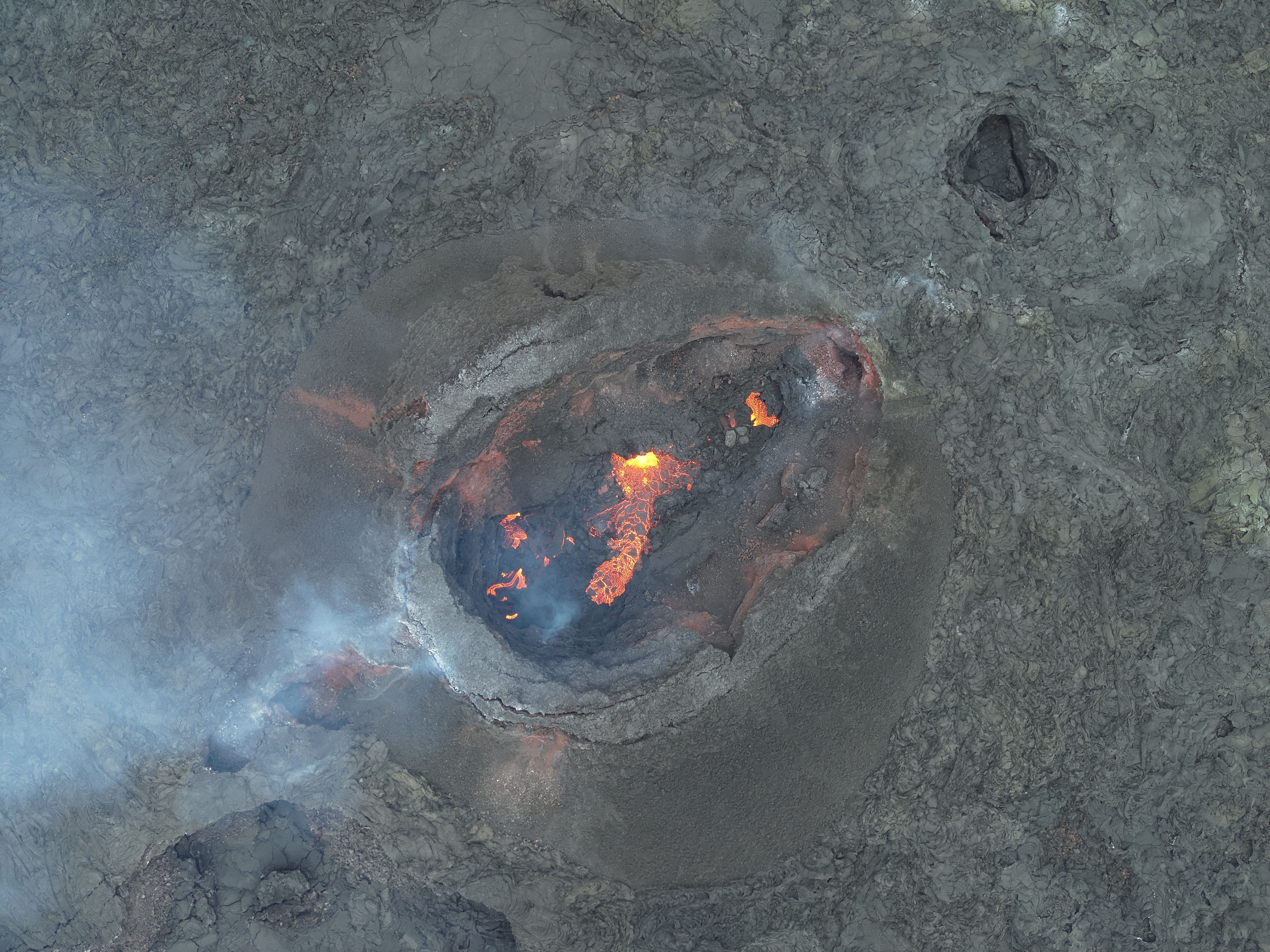
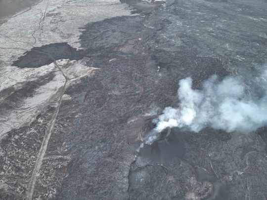 From the Civil Defense patrol flight on May 9. No lava splashes are visible in the crater, although smoke continues to pour out of it. (Photo: Civil Defense)
Magmatic dike propagation and/or volcanic eruption is likely to occur again
Updated 28 June at 17:00 UTC
- Lava field has an area of 9.3 km² and a volume of approximately 45 million m³
- The uplift at the Svartsengi region continues at an elevated rate
- Data collected in the coming days/weeks will help assess the situation with more certainty
The seismic activity near Svartsengi and Sundhnúks is very minor with few small earthquakes detected in the past few days. The lava field which progressed towards the NW of Sýlingarfell continued to move very slowly since the eruption ended on 22 June, and it has now completely stopped.
A team from the Institute of Natural History and the National Land Survey has processed data collected by experts from Efla, Verkís, and Svarmi during drone flights over the eruption sites on 24 June. This data reveals that the lava field now has an area of 9.3 km² and a volume of approximately 45 million m³.
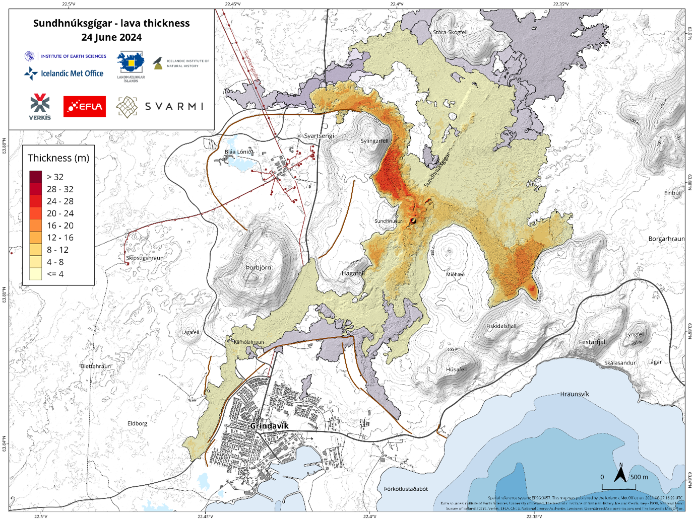 Extension and thickness of lava field emplaced during the eruption in Sundhnúk crater row, which began on 29 May and lasted until 22 June 2024.
Uplift underneath the Svartsengi region continues
The most recent ground deformation data (both GNSS and satellite InSAR images) show that the uplift underneath the Svartsengi region continues. The rate of the uplift is currently assessed to be higher than the rate observed before the eruption which started on 29 May. The rate of ground deformation can be interpreted as a continuous magma inflow into the magma body at 4-5 km depth.
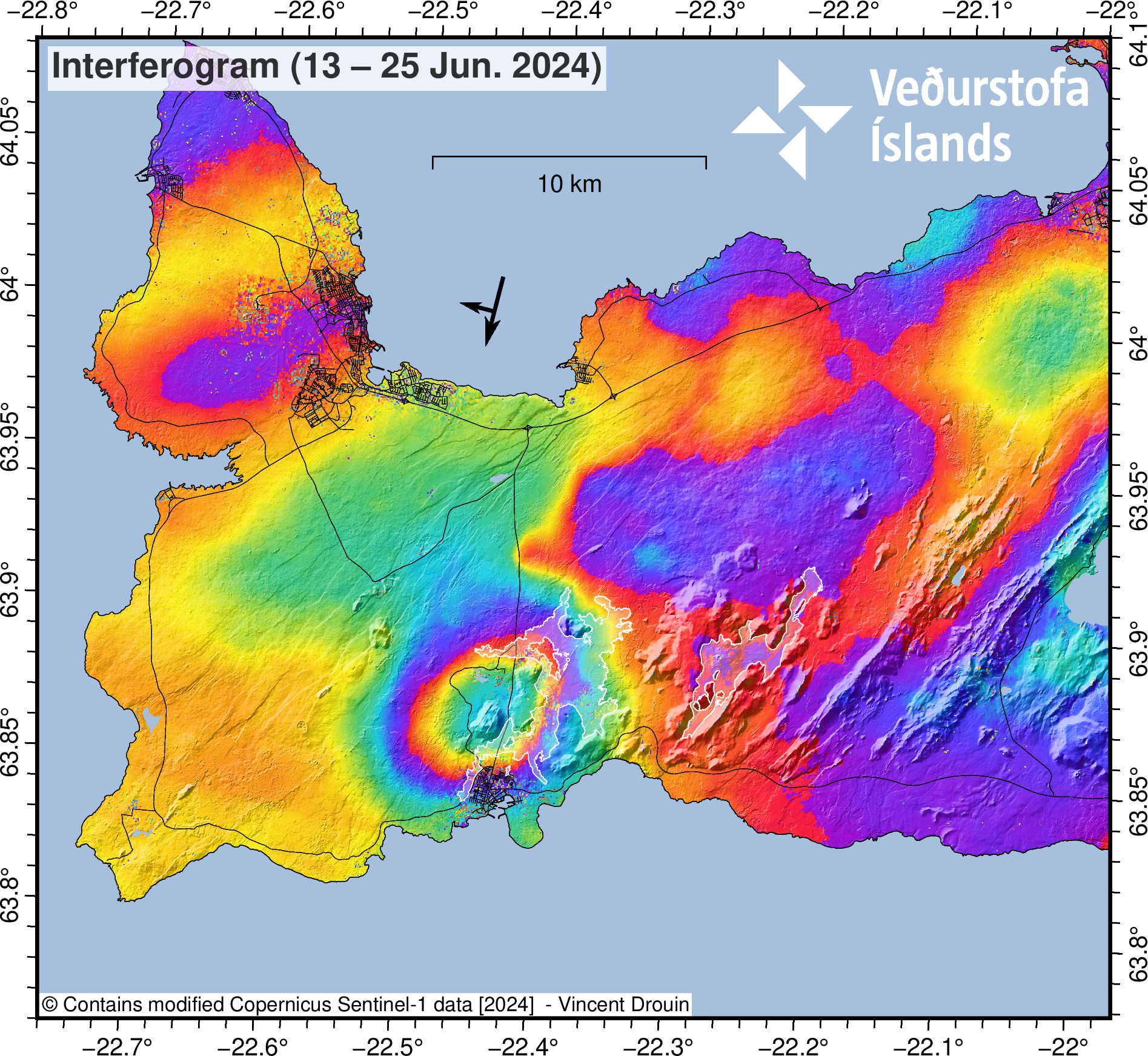 Interferogram (InSAR) for the period 13 - 25 June shows that deformation in that period is around 3-4 cm. The image is based on data from the Sentinel-1 satellite. The areas with white contours correspond to the extension of lava fields in the Fagradalsfjall and Sundhnúks regions.
With these premises, it is expected that the system will behave in a similar manner as before and that a new magmatic dike propagation and/or volcanic eruption will occur again in the Sundhnúks region in the coming weeks. As of today, it is difficult to anticipate with certainty how the situation will progress. The data collected in the coming days/weeks will help assess the situation and, possibly, understand changes and evolution within the magmatic system.
Updated 24. June at 15:00 UTC
- The eruption that began on May 29 has ceased, having lasted for 24 days
- This was the fifth eruption in the Sundhnúksgígaröð series since December 2023
- Ground uplift has been steady but at a slower rate than between the previous eruptions
The eruption that began in the Sundhnúksgígaröð series on May 29 has ceased, with no activity observed in the crater since June 22. The eruption lasted for 24 days and was the fifth in the Sundhnúksgígaröð eruptive series since December 2023. Additionally, the lava field formed during this eruption is the largest by volume and area.
Although no lava is actively flowing from the crater, significant movements continue in the lava field north of Sýlingarfell due to still-molten lava beneath the solidified surface. In the last two days, activity has been observed in the lava tongues that crossed the defensive barrier at Sýlingarfell and in the lava field north of the barrier. Movement in the lava field is expected to continue in the coming days, as this process takes considerable time to stop.
Approximately ten days after the eruption began, ground uplift in Svartsengi resumed, indicating ongoing magma accumulation. The ground uplift has been steady since then, but the rate is slower than what was observed between the previous events. The Icelandic Meteorological Office continues to monitor the area, and measurements in the coming days and weeks will help scientists interpret any developments in the geological activity.
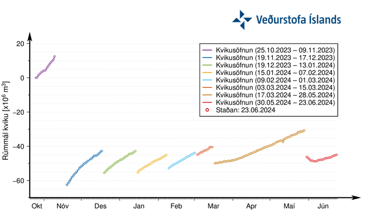 A graph showing the progression of magma accumulation and the estimated total volume of magma beneath Svartsengi between the series of intrusions and eruptions, spanning October 25, 2023, to the present. The values presented are based on models using geophysical data. The red dots show the status since May 30, 2024, indicating that the rate of magma accumulation is now slower than in previous periods of accumulation.
While magma accumulation continues beneath Svartsengi, it is likely that the recent pattern of magma intrusions and eruptions will continue. At this time, it is difficult to predict when the next event will occur or when magma accumulation will cease.
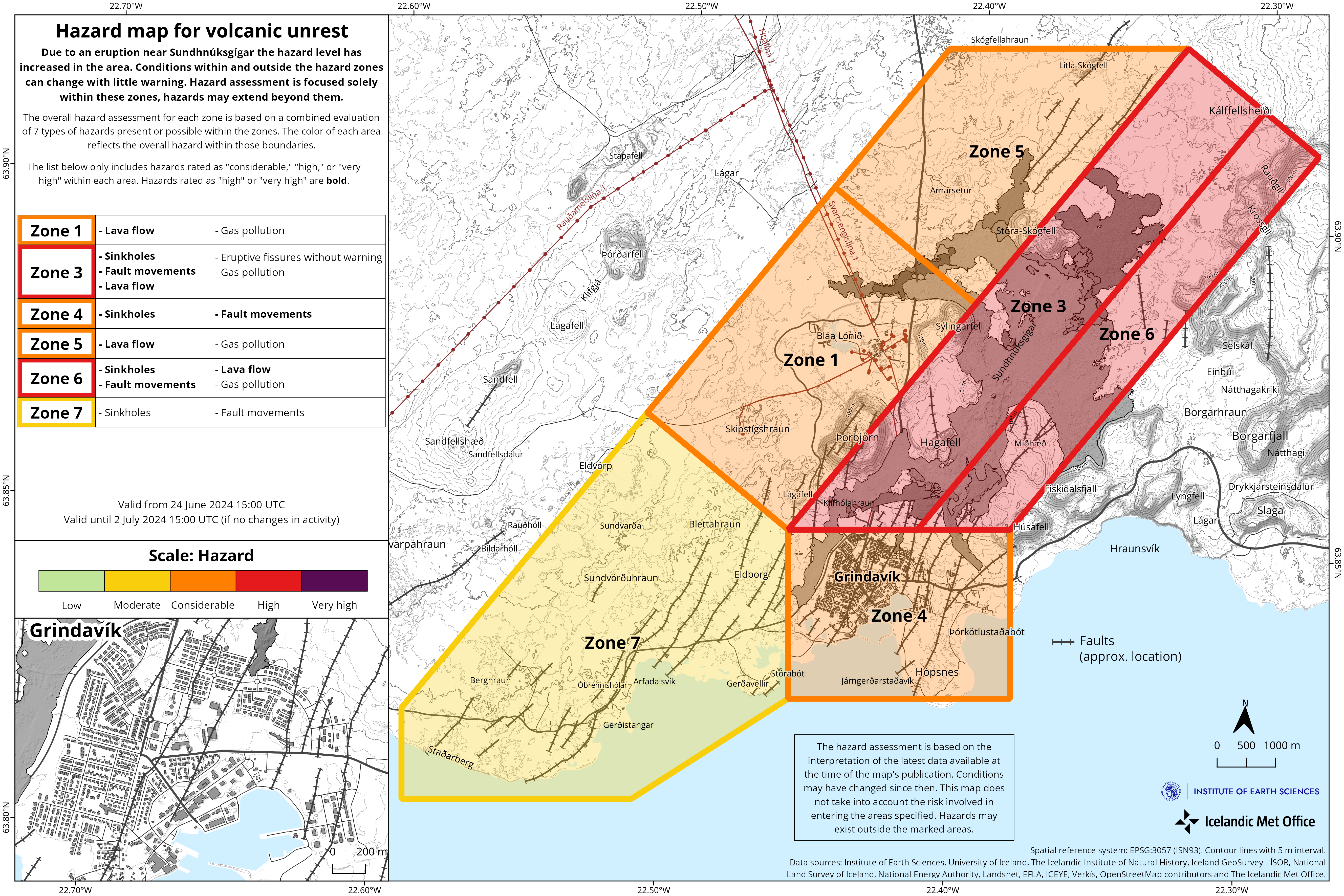
Updated Hazard Assessment
The Icelandic Meteorological Office has issued an updated hazard assessment. The end of the last eruption has led to changes in several areas. The hazard is assessed to be lower in all areas due to the reduced likelihood of lava flow and gas pollution. Experts from the Icelandic Meteorological Office measured gas emissions from the crater on Friday, June 21 to be very low, approximately 1 kg/s.
Updated 22. June at 19:00 UTC
The eruption that began on May 29th appears to be over. Yesterday, there was little activity visible in the crater, and during a Civil Protection drone survey at noon today, no activity was observed. Additionally, the tremor on nearby seismometers has decreased and is now comparable to what was measured before the eruption began.
However, it is expected that older lava will continue to flow slowly for a little longer along the northern side of Sýlingarfell and at defense barrier L1, where lava tongues have flowed over.
 Picture of the crater captured around noon today during a Civil Protection drone flight over the eruption site. Photo: Civil Protection
Updated 21. June at 18:00 UTC
Images captured this morning during a Civil Protection drone flight clearly show that activity in the crater is decreasing. Lava flows from the crater are not visible on the surface but may continue in closed channels. However, there is still lava actively flowing in the lava tongues that went over the defense barrier north of Sýlingarfell yesterday. A picture from the Civil Protection webcam on Sýlingarfell shows the three lava tongues flowing over the barrier and machinery being used to contain the lava flow. The westernmost lava tongue appears to be the most active, having advanced forward several meters and thickened in the last few hours. The eruption tremor is also decreasing, which is clearly observed on the Meteorological Office's seismometer in Grindavík, as shown in the accompanying graph.
The decreasing visible activity in the crater and the reduction in eruption tremor suggest that this eruption may end soon, though there is uncertainty about the exact timing. GPS measurements still show land uplift in the Svartsengi area. This indicates that pressure in the magma chamber under Svartsengi continues to build, although the rate of uplift is slower than before.
 Picture of the crater captured around 9:30 this morning during a Civil Protection drone flight over the eruption site. Photo: Civil Protection
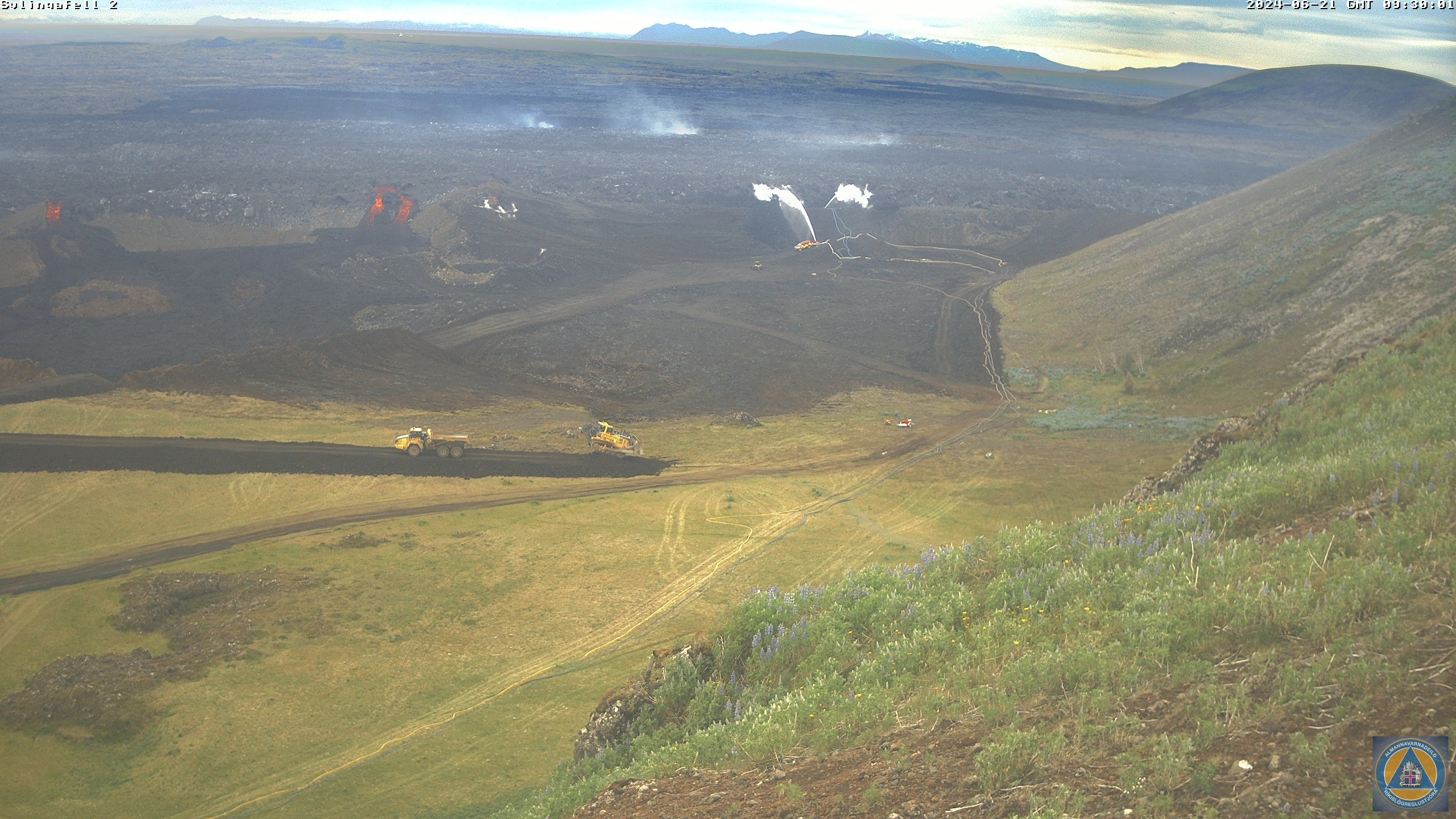 The lava tongues flowing over the defense barrier north of Sýlingarfell and efforts to contain the lava flow. Photo: Civil Protection
- CategoriesEdited | Front Page Stories | All Content | Disasters | Earthquakes | Volcanos | Government | Science | Europe | Atlantic Ocean | News | News -- WNT Selected
- CreatedFriday, June 28, 2024
- Last modifiedSunday, June 30, 2024
SUBSCRIBE

World Desk Activities

phys.org/news/2024-07-mrna-technology-cells-drug-f…

New mRNA technology turns cells into long-lasting drug factories
A team of researchers has established a ribonucleic acid (RNA)-based method that drives cells in the body to produce therapeutic proteins and secrete them into…
phys.org/news/2024-07-astronomers-strong-front-gal…
Astronomers observe a strong shock front in galaxy cluster SPT-CLJ 2031-4037
Using NASA's Chandra X-ray spacecraft, astronomers from the University of Alabama in Huntsville have observed a merging galaxy cluster known as SPT-CLJ 2031-4037. They detected…
phys.org/news/2024-07-ant-amputates-infected-limbs…
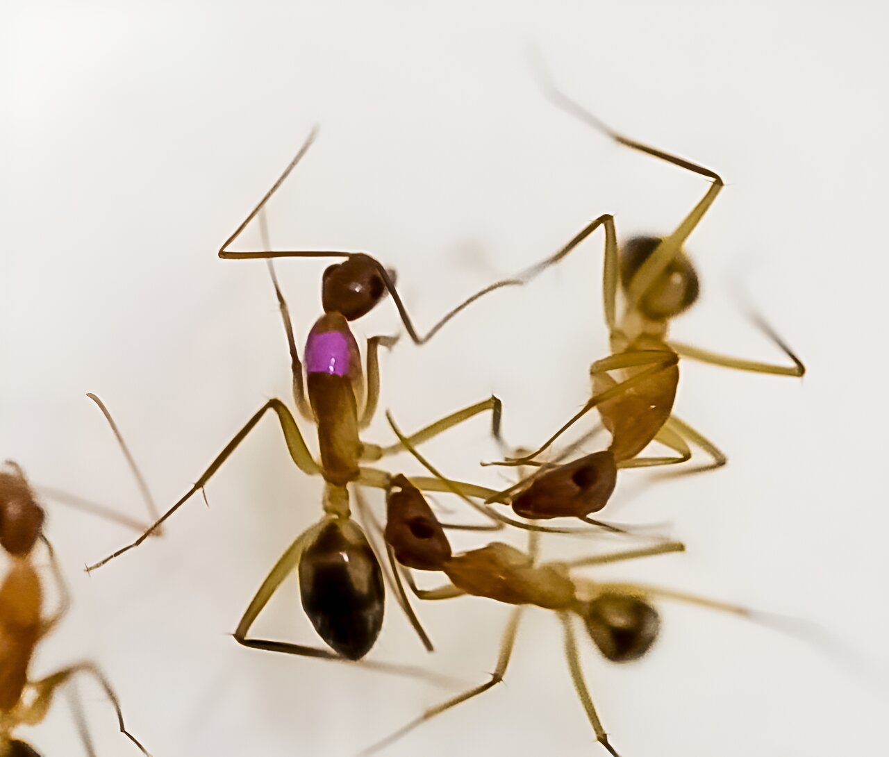
Ants perform amputations to save injured nestmates
Saving lives through surgery is no longer exclusive to humans. In a study published July 2 in the journal Current Biology, scientists detail how Florida…
www.betterup.com/blog/what-is-self-awareness

Self-Awareness: What Is It & How to Develop It
If you want to become a happier person, more effective leader, and better decision-maker, self-awareness is the most important skill to have.
![The Smiths - How Soon is Now. 1984 (Full 12" Extended Video Version)[Remastered Audio]](https://img.youtube.com/vi/33-5bsbQj-w/maxresdefault.jpg)
Latest Stories


Electronic Frontier Foundation
- Careful with your marshmallows 🔥 July 02, 2024
- Podcast Episode: Fighting Enshittification July 02, 2024
- Keep The Momentum Going for The Right to Repair July 01, 2024
- Victory! Supreme Court Rules Platforms Have First Amendment Right to Decide What Speech to Carry, Free of State Mandates July 01, 2024
The Intercept
- Understanding Israel’s “System of Domination” July 03, 2024
- Every Democrat Other Than Joe Biden Is Unburdened by What Has Been July 02, 2024
- Missouri’s Attorney General Isn’t MAGA Enough for Leonard Leo July 02, 2024
- The Supreme Court Wants a Dictator July 01, 2024
VTDigger
- Vermont selected to take part in federal health care reform model July 03, 2024
- Frank Knaack and Falko Schilling: The U.S. Supreme Court and Vermont’s homelessness crisis July 03, 2024
- Tim de la Bruere: Abenaki people were excluded from the state recognition process. I was one of them. July 03, 2024
- Displaced by floods, Berlin manufactured home park residents seek to prevent a repeat disaster July 03, 2024
