
Iceland Volcano: Grindavíkurvegur Under Lava For Third Time Since Volcanic Activity Started At Sundhnúkur -- Iceland Met Office
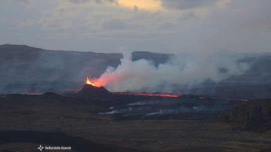
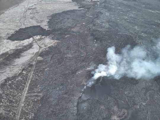 From the Civil Defense patrol flight on May 9. No lava splashes are visible in the crater, although smoke continues to pour out of it. (Photo: Civil Defense)
Little movement of the lava tongue since noon
Updated 8 June at 16:20 UTC
Continuing activity in one crater which remains relatively stable.
Last night, the lava flow increased north of Sýlingarfell and towards Grindavíkurvegur.
The lava tongue reached the road around half past ten this morning.
The front of the lava field is about 800 meters away from the hot water pipelines.
The eruption on the Sundhnúksgígaröð continues and it has now been ten days since it started. Since Tuesday, June 4th, one crater has been active. In the past few days, the lava has mostly flowed northwest and thickened near Sýlingarfell, as well as slowly flowing north past Sýlingarfell and west. Night to Saturday, the lava flow north of Sýlingarfell towards the west and towards Grindavíkurvegur, increased. This morning, Saturday, efforts were made to close the gap in the protective barrier at Grindavíkurvegur, and around half past ten, the lava tongue reached the road just north of the barrier. Lava has also flowed down along the barrier and is very thick near it, crumbling over the barrier in places. The speed of the lava flow has decreased since noon. The front of the lava field has reached about 800 meters away from the hot water pipelines and is slowly moving towards them.
It can be concluded that the current surge is over, but it is expected that it will continue to move slowly forward. The situation will be closely monitored, and another surge cannot be ruled out in the coming days.
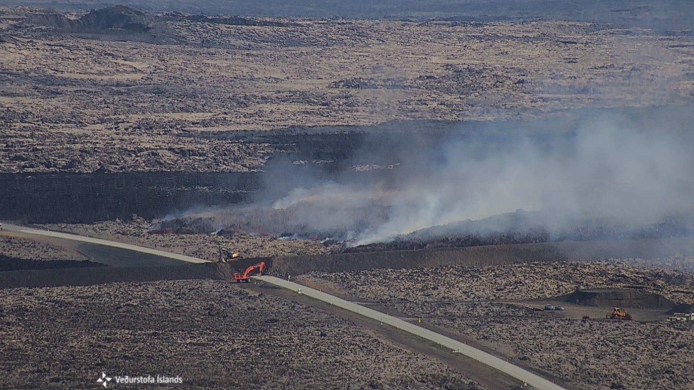 The picture was taken at 10:10 this morning by a camera owned by the Icelandic Meteorological Office, located on Þorbjörn. It shows the lava front moving towards Grindavíkurvegur and workers in the area closing an opening in the protective barrier L1.
Updated 7. June at 18:00 UTC
Stable eruptive activity continues in one crater.
Lava is primarily flowing to the northwest.
Land subsidence has stopped in Svartsengi.
The hazard assessment has been updated. Gas pollution may be noticed in Grindavík.
The eruption at the Sundhnúkur crater row continues and has been ongoing for nine days. Since Tuesday, June 4, one crater has been active. Lava from this crater primarily flows northwest towards Sýlingarfell, where the lava field is thickening; from there, active lava streams are moving north of Sýlingarfell.
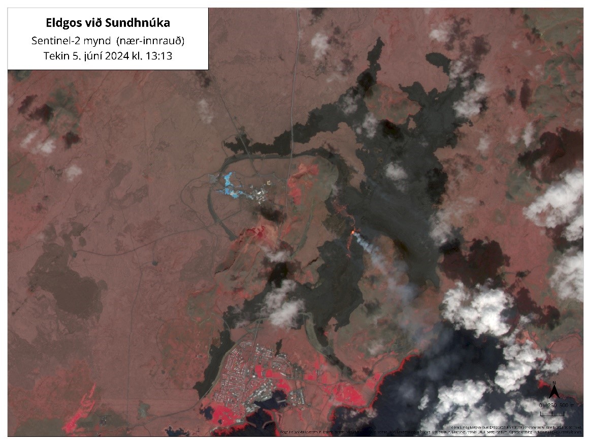 Satellite image from June 5th, showing active lava flows from the crater flowing northwest towards Sýlingarfell and south towards Hagafell. This image is a so-called "near-infrared" thermal image, which highlights the difference between hot and cold surfaces in the landscape and clearly distinguishes lava fields and lava flows in the landscape.
A team from the Institute of Natural History and the National Land Survey has processed data collected by experts from Efla, Verkís, and Svarmi during a drone flight over the eruption sites on June 3rd. This data reveals that the lava field now has an area of 8.6 km² and a volume of approximately 36 million m³.
Based on these measurements, the estimated average flow rate of lava from the eruption spanning the period from the afternoon of May 29th to June 3rd is approximately 30 m³/s. These results are based on data covering about 70% of the lava field, assuming that there have been no significant changes in the lava field outside of this area between measurements. After these measurements were obtained, the eruption's activity changed, reducing the number of active craters to a single crater that has been active since June 4th. There are no measurements of lava flow rate since then, but for comparison, the lava flow from the last eruption in the Sundhnúkur crater row was estimated to be approximately 3-4 m³/s when only one crater was active.
In the first few days after the eruption began, land subsidence was measured in Svartsengi, indicating that more magma was flowing out of the magma reservoir and to the surface than was flowing into the reservoir from the depth. Deformation measurements in recent days show that land subsidence seems to have stopped, suggesting that the magma flow from the depth into the magma reservoir is now comparable to the flow towards the surface at the Sundhnúkur crater row.
The following graph shows the estimated volume of magma that has accumulated beneath Svartsengi between the series of eruptions and dike intrusions since November 2023. The red line marks model calculations from May 30th, indicating that the volume of magma under Svartsengi decreased in the first days after the eruption began. However, the most recent data points indicate that the volume of magma under Svartsengi is stable. This suggests that the magma flow from depth into the magma reservoir and up to the surface in the Sundhnúkur crater row is comparable. For more detailed information on magma accumulation beneath Svartsengi, see the previous news report.
Monitoring potential changes in the magma reservoir beneath Svartsengi
As mentioned in the last news update, this was the first instance since the volcanic unrest began at the Sundhnúkur crater row in December 2023 that land subsidence was measured in Svartsengi during an eruption. Yesterday, the University of Iceland's Institute of Earth Sciences released the first rock and geochemical data from the ongoing eruption. Their analysis reveals that the composition of the magma currently reaching the surface is different from that of the last four eruptions at the Sundhnúkur crater, instead resembling magma from the beginning of the eruption in Geldingadalur in 2021. These results indicate that the magma reservoir beneath Svartsengi is evolving. At this point, it is not possible to definitively state the nature of these changes. More data will be collected and analyzed in the near future to allow a clearer interpretation of this evolution.
Important to regularly monitor gas pollution forecasts
The weather forecast predicts northerly winds today and tomorrow. Therefore, gas pollution will be carried south, potentially affecting Grindavík. There is still considerable uncertainty about the quantity of gases being emitted from the eruption site. Real-time measurements of various gases can be monitored on the website loftgaedi.is, and the Icelandic Meteorological Office's gas distribution forecast can be found here.
The hazard assessment has been updated due to developments in the eruption, in addition to the weather and gas distribution forecasts. The hazard assessment remains largely unchanged, except for Zone 7 where the hazard for gas pollution has increased.
 (Click on the map to see it larger)
Updated 4. June at 18:30 UTC
The eruption has been ongoing for six days.
One crater remains active.
Lava has primarily flowed northwest towards Sýlingarfell.
New data reveals it is likely that magma continues to accumulate beneath Svartsengi.
The hazard assessment remains largely unchanged.
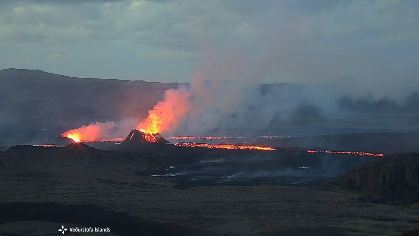
The eruption that began on May 29 at the Sundhnúkur Crater Row has now persisted for six days. After a relatively vigorous start, eruptive activity consolidated into three vents that remained active over the weekend. Changes in activity were observed last night, with only one crater appearing to remain active today. (See the location of the active crater on the hazard map.) The active crater is adjacent to the crater that previously exhibited the most extensive activity during the previous eruption, which lasted from March 16 to May 9.
Lava from the active crater flows northwest towards Sýlingarfell and continues to flow northward. Additionally, there are active lava flows moving southward towards Hagafell. Now that activity has shifted to a single crater, it is likely that the lava flow travelling southeast towards Fiskidalsfjall has diminished.
Accompanying this update are two images from the Icelandic Meteorological Office's web camera located on Þorbirn, which overlooks the eruption site. The first image, taken at 02:00, shows magma coming up from two craters, while the second image taken an hour later only shows magma coming from the larger crater.
Magma Likely Continues to Accumulate Beneath Svartsengi as Before
Inclinometer measurements indicate that the land continues to subside at Svartsengi. When the dike intrusion began in the lead-up to the current eruption on May 29, the land subsided by 15 cm at Svartsengi. However, it has since subsided an additional 4-6 cm in the following days. The prolonged land subsidence after the eruption's onset is unlike what has been observed in previous eruptions at the Sundhnúkur Crater Row.
In previous eruptions, nearly all subsidence occurred simultaneously with the initial days of activity, followed by a gradual emerging trend of land uplift. The current pattern of subsidence suggests that, at this stage, a greater volume of magma is flowing out from the magma reservoir beneath Svartsengi into the Sundhnúkur Crater Row than is flowing into the reservoir from depth.
Ongoing deformation measurements in the Svartsengi area and the evolution of volcanic activity in the coming days will provide a clearer picture of the continued magma accumulation beneath Svartsengi. However, numerical modeling and lava flow assessments of the eruption indicate that magma accumulation persists, as it has in previous eruptions.
Updated Hazard Assessment
Today's weather forecast (Tuesday) indicates a northerly wind, which will likely cause volcanic gas emissions to drift southward, posing a risk of pollution in Grindavík. Tomorrow, with a northwesterly wind, gas emissions will shift towards the southeast. There is significant uncertainty regarding the magnitude of gas emissions from the eruption site. Real-time measurements of various volcanic gases can be monitored on the website loftgaedi.is.
The hazard assessment has been updated, in light of the ongoing volcanic activity and weather forecasts. Overall, it remains largely unchanged, but Zone 7 has been downgraded to a moderate risk level (yellow). Zone 3, near the Sundhnúkur Crater Row and the eruption site, continues to pose a high risk (dark blue). Zones 4 (Grindavík) and 6 remain at a significant risk level (red), while Zones 1 and 5 are at a notable risk (orange). This map remains valid until June 7.
 (Click on the map to see it larger)
- CategoriesEdited | All Content | Disasters | Earthquakes | Volcanos | Government | Science | Europe | Atlantic Ocean | News -- WNT Selected
- CreatedSaturday, June 08, 2024
- Last modifiedTuesday, June 18, 2024
SUBSCRIBE
Sign up for our weekly newsletter and World News Trust project updates.

World Desk Activities

www.imf.org/en/News/Podcasts/All-Podcasts/2024/05/…
en.vedur.is/about-imo/news/volcanic-unrest-grindav…

www.sciencealert.com/shift-in-indias-vulture-popul…
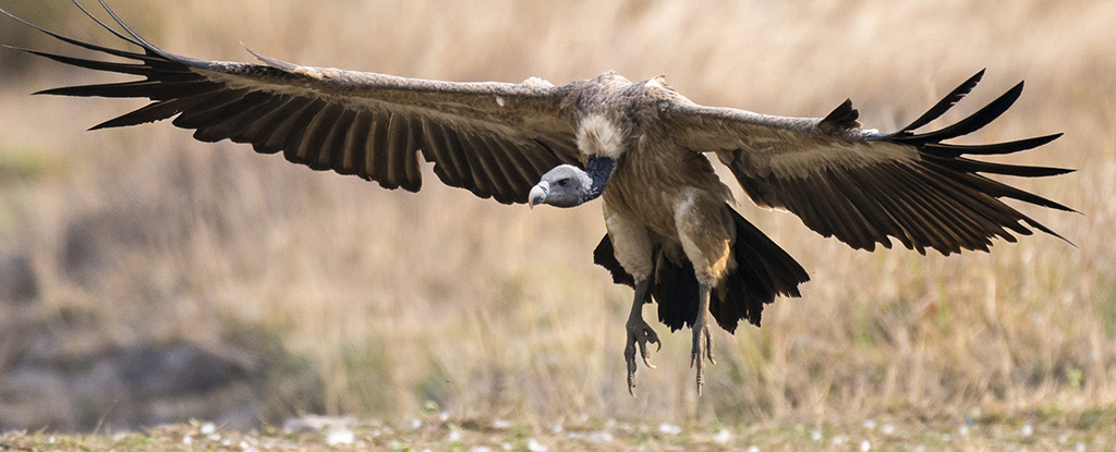
Shift in India's Vulture Population Linked to Half a Million Human Deaths : ScienceAlert
A cattle painkiller introduced in the 1990s led to the unexpected crash of India's vulture populations, which still haven't recovered to their former glory.

Tad author feed item to community feed
Latest Stories


Electronic Frontier Foundation
- Digital Apartheid in Gaza: Unjust Content Moderation at the Request of Israel’s Cyber Unit July 26, 2024
- Electronic Frontier Foundation to Present Annual EFF Awards to Carolina Botero, Connecting Humanity, and 404 Media July 25, 2024
- Briefing: Negotiating States Must Address Human Rights Risks in the Proposed UN Surveillance Treaty July 24, 2024
- Journalists Sue Massachusetts TV Corporation Over Bogus YouTube Takedown Demands July 24, 2024
The Conversation
- Vale Ray Lawler: the playwright who changed the sound of Australian theatre
- Magnificent and humbling: the Paris opening ceremony was a tribute to witnessing superhuman feats of the extraordinary
- How collaboration from across Canada, and the world, is helping fight the Alberta wildfires
- Paris Olympics: Canada’s soccer drone scandal highlights the need for ethics education
The Intercept
- Honduras, 15 Years After the Coup: An Interview With Ousted President Manuel Zelaya July 26, 2024
- Google Planned to Sponsor IDF Conference That Now Denies Google Was Sponsor July 25, 2024
- Deputy Accused of Killing Sonya Massey Was Discharged From Army for Serious Misconduct July 25, 2024
- U.S. Has Never Apologized to Somali Drone Strike Victims — Even When It Admitted to Killing Civilians July 25, 2024
VTDigger
- Waterbury residents looked to FEMA buyouts after last year’s floods. They’ve heard nothing for months July 26, 2024
- At a quiet Craftsbury pond, rowers become Olympians July 26, 2024
- UVM Medical Center wins approval to buy Fanny Allen Campus July 26, 2024
- Landslides and slurries have damaged homes, roads and driveways after this month’s flood July 26, 2024
