
Iceland Volcano: Decreased Eruption Activity -- Iceland Met Office
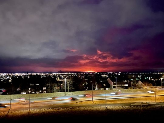 The eruption seen from the balcony of the National Weather Service on Bústaðaveg
Activity at three locations on the fissure
Updated 17 March at 13:00 UTC
The volcanic eruption that began at 20:23 last night continues, but during the night the intensity of the eruption decreased, and now there are three active openings on the eruptive fissure. Seismic activity also significantly decreased overnight, with very few earthquakes measured after 3:00, coinciding with a decrease in volcanic tremor. This development is very similar to the three previous eruptions on the Sundhnúkur crater row.
Shortly after midnight, lava flowed over the Grindavík road towards the water distribution pipe from Svartsengi power plant. There has been limited advancement in that lava flow front since this morning and it is now about 200 meters from the pipe. Another lava flow front runs alongside the protective barriers east of Grindavík and towards Suðurstrandarvegur road. Response workers in the area are monitoring the lava's advance rate, which has been slow and steady since this morning.
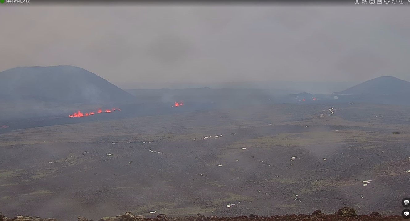 The eruption fissure as it was at 11:00 today. To the right of the image is Mt. Stóra-Skógafell, and to the left is Mt. Sýlingarfell. The most active part of the fissure is east of Sýlingarfell, with smaller openings to the north.
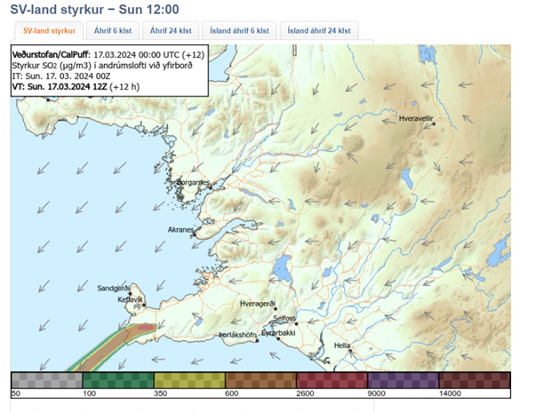
Today's weather forecast is northeast winds of 8-13 m/s with intermittent rain, but the wind will gradually decrease. Gas emissions will mainly drift southwest from the eruption site. Tomorrow, southeast winds of 8-13 m/s are expected with showers, and the gas emissions will likely drift northwest. Temperatures generally range from 1 to 5 degrees Celsius near the eruption sites. There is considerable uncertainty regarding the intensity of gas emissions. See the gas dispersion forecast here.
Updated 17 March at 01:25 UTC
The Icelandic Met Office has updated the hazard map for the area. Lava flow continues to the south and southeast. The speed of the lava front is estimated to be 1 km/hr.
If the eruption continues at the same rate the scenario of lava reaching the ocean needs to be considered.
Now, about five hours into the eruption, the activity has been fairly constant for the whole length of the fissure.
 (Click map to enlarge)
Updated 16 March at 23:50 UTC
A volcanic eruption has begun between Mt. Hagafell and Mt. Stóra Skógfell. The eruption began at 20:23 UTC on 16 March, with a 2.9-km-long fissure forming quickly. The length and location of the fissure is similar to the eruption on 8 February 2024.
The pre-eruptive warning phase was very short. The first warning to the Department of Civil Protection and Emergency Management was at 19:43 UTC, and the onset of eruption was confirmed on web cameras just 40 minutes later. The eruption is effusive in nature, so the eruption plume consists mainly of steam and gas.
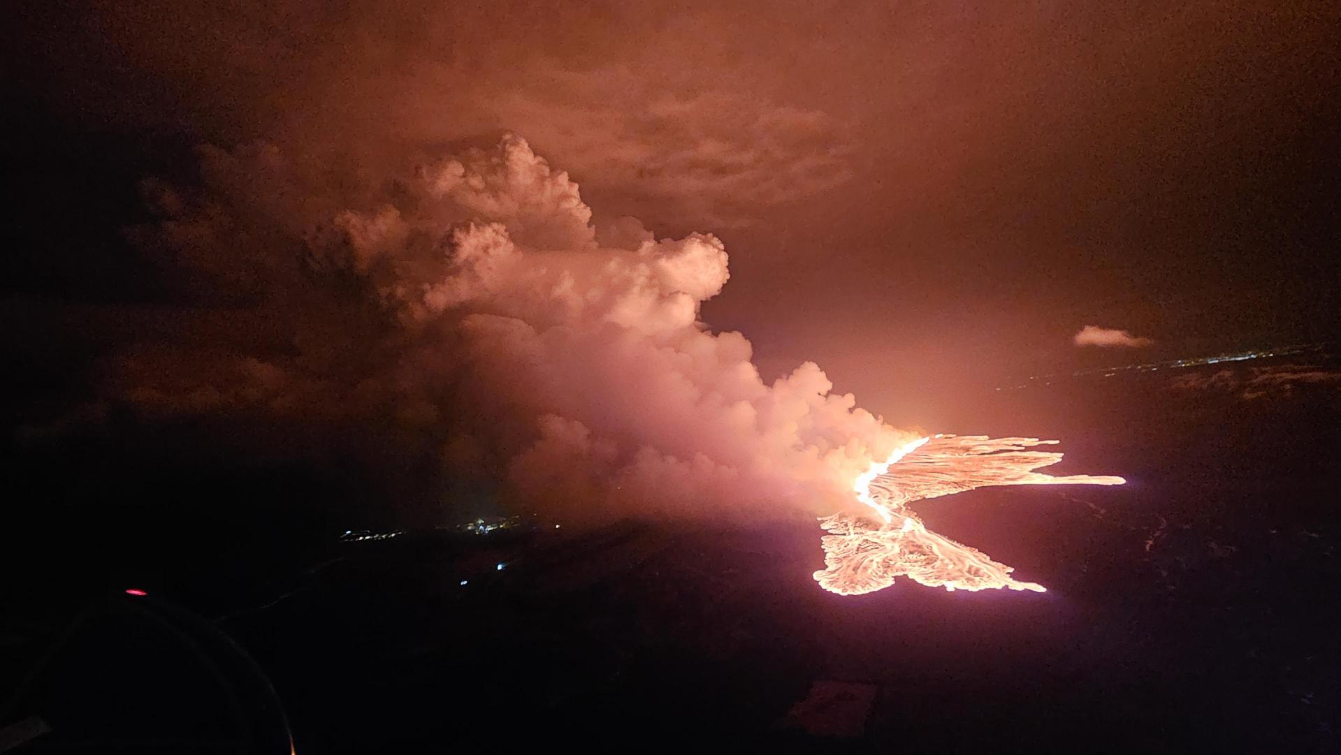 Picture showing the status of the eruption at 21:40. (Photo: DCPEM/Björn Oddsson)
The Icelandic Coast Guard performed a helicopter flight over the eruption area. The flight had experts from IMO, the University of Iceland, the Department of Civil Protection and Emergency Management. Lava is flowing westward from the eruption fissure in the direction of Grindavíkurvegur (road) and the protection barriers for the Svartsengi region. Additionally, a large lobe of lava is flowing southeast toward the protection barriers for Grindavík.
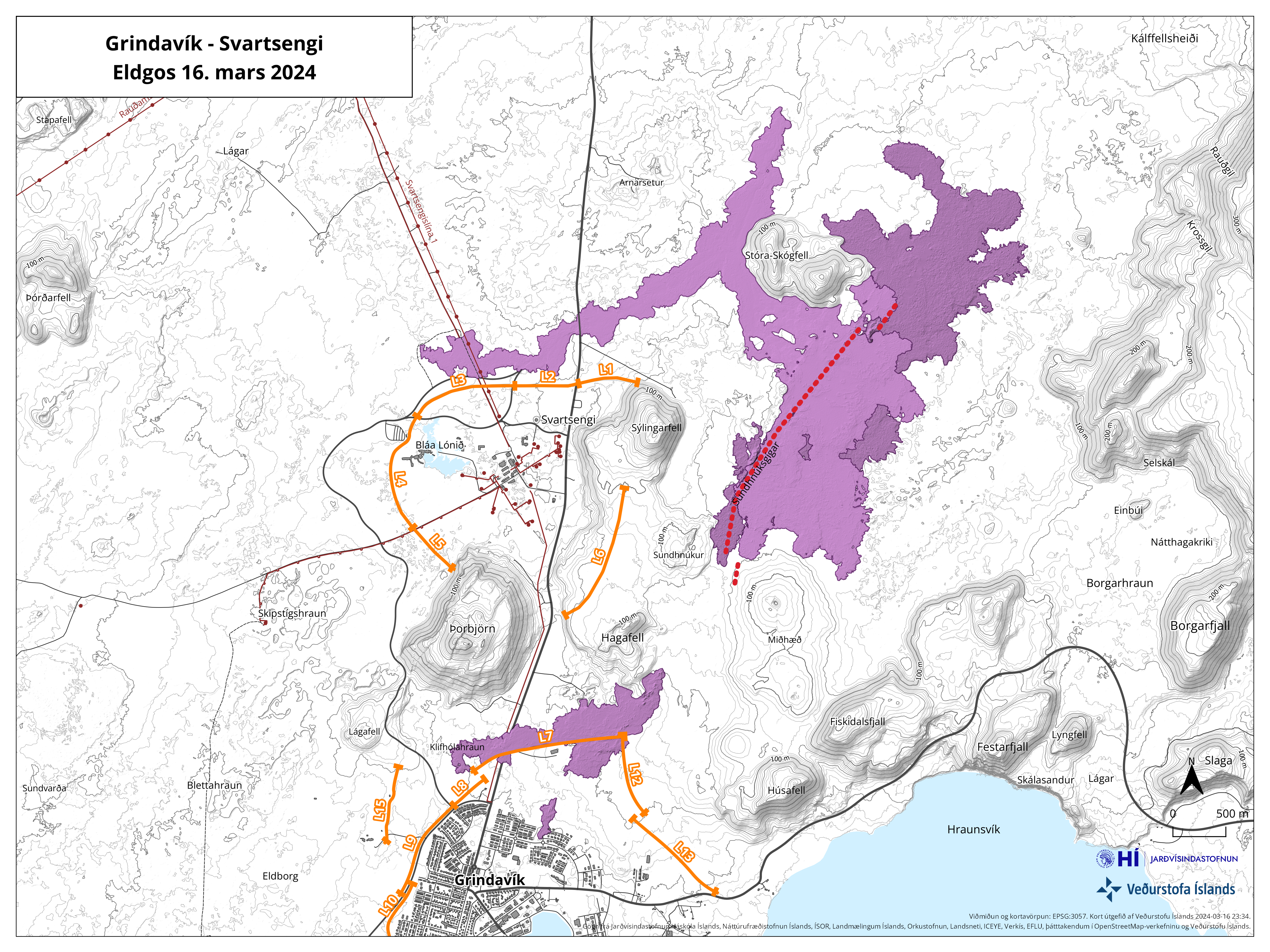 The map shows the fissure opening in red. Orange lines show lava barriers. (Click map to enlarge)
From initial assessments of web camera imagery and aerial photographs from the helicopter flight, the eruption is thought to be the largest (in terms of magma discharge) of the three previous fissure eruptions from the Sundhnúkur crater row. This estimate applies to the first hour of eruptive activity.
At 22:10 UTC, the southern lava front was just 200 m from the barriers on the eastern side of Grindavík and moving at a rate of about 1 km per hour. At 22:20 UTC, lava was 700 to 800 m away from Grindavíkurvegur, northwest of Grindavík, moving at a rate of approximately 1 km in 1.5 hours.
- CategoriesEdited | All Content | Disasters | Earthquakes | Volcanos | Government | Science | Europe | Atlantic Ocean | News | News -- WNT Selected
- CreatedSunday, March 17, 2024
- Last modifiedMonday, March 18, 2024
SUBSCRIBE
Sign up for our weekly newsletter and World News Trust project updates.

World Desk Activities

www.imf.org/en/News/Podcasts/All-Podcasts/2024/05/…
en.vedur.is/about-imo/news/volcanic-unrest-grindav…

www.sciencealert.com/shift-in-indias-vulture-popul…
Shift in India's Vulture Population Linked to Half a Million Human Deaths : ScienceAlert
A cattle painkiller introduced in the 1990s led to the unexpected crash of India's vulture populations, which still haven't recovered to their former glory.

Tad author feed item to community feed
Latest Stories


Electronic Frontier Foundation
- Digital Apartheid in Gaza: Unjust Content Moderation at the Request of Israel’s Cyber Unit July 26, 2024
- Electronic Frontier Foundation to Present Annual EFF Awards to Carolina Botero, Connecting Humanity, and 404 Media July 25, 2024
- Briefing: Negotiating States Must Address Human Rights Risks in the Proposed UN Surveillance Treaty July 24, 2024
- Journalists Sue Massachusetts TV Corporation Over Bogus YouTube Takedown Demands July 24, 2024
The Conversation
- Vale Ray Lawler: the playwright who changed the sound of Australian theatre
- Magnificent and humbling: the Paris opening ceremony was a tribute to witnessing superhuman feats of the extraordinary
- How collaboration from across Canada, and the world, is helping fight the Alberta wildfires
- Paris Olympics: Canada’s soccer drone scandal highlights the need for ethics education
The Intercept
- Honduras, 15 Years After the Coup: An Interview With Ousted President Manuel Zelaya July 26, 2024
- Google Planned to Sponsor IDF Conference That Now Denies Google Was Sponsor July 25, 2024
- Deputy Accused of Killing Sonya Massey Was Discharged From Army for Serious Misconduct July 25, 2024
- U.S. Has Never Apologized to Somali Drone Strike Victims — Even When It Admitted to Killing Civilians July 25, 2024
VTDigger
- Waterbury residents looked to FEMA buyouts after last year’s floods. They’ve heard nothing for months July 26, 2024
- At a quiet Craftsbury pond, rowers become Olympians July 26, 2024
- UVM Medical Center wins approval to buy Fanny Allen Campus July 26, 2024
- Landslides and slurries have damaged homes, roads and driveways after this month’s flood July 26, 2024
