
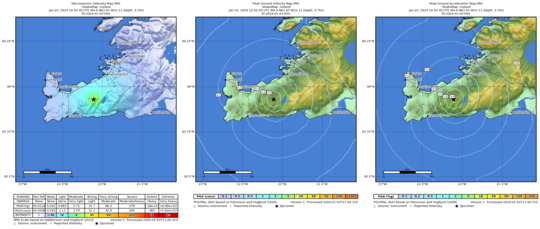
Iceland Volcano: Earthquakes Near Trölladyngja -- Iceland Met Office
The largest earthquake was 4.5 in magnitude, according to initial data. Shortly afterward, a magnitude 3.9 earthquake occurred
Information is updated regularly here and on X (Formerly known as Twitter).
Updated 4 January at 12:30 UTC (7:30 EST)
At 10:50 a.m., an earthquake of magnitude 4.5 occurred near Trölladyngja, followed shortly by another earthquake measuring 3.9 at 10:54 a.m. and a series of aftershocks. The earthquakes occurred at a depth of approximately 5 km and were likely triggered in response to stress released from earth movement elsewhere on the Reykjanes Peninsula. These earthquakes were widely felt in the southwest region of Iceland.
The location of the earthquakes is about 20 km NNE of Svartsengi, where land rise due to magma accumulation is ongoing.
The accompanying image shows the location of the earthquake that occurred at 10:50 AM and its impact area.
Updated 2 January at 14:00 UTC
The rate of ground displacement at Svartsengi is decreasing. Experts gathered at the Meteorological Office this morning confirmed this through an analysis of GPS data.
The deceleration of inflation is an indication that magma pressure is rising, increasing the chances of new dike intrusion and also volcanic eruption. This is a similar change in ground displacement that was observed at the end of the day on December 15, which culminated in an eruption three days later. However, it is difficult to assert whether this pattern will repeat.
The first signs of an impending volcanic eruption are a sudden increase in seismic activity, and such signs were observed shortly before the eruption began on December 18.
In recent days, seismic activity in the area has been relatively consistant, with around 200 earthquakes recorded per day. Most of the earthquakes measure below magnitude 1.0, but around 30 earthquakes with magnitudes exceeding 1.0 have been recorded since December 29, with the largest being a magnitude 2.1 located in the northern part of Grindavík.
Continued scientific assessment indicates that, should an eruption occur, the Sundhnúkur crater row, between Stóra-Skógafell and Hagafell, is the most probable location for an eruption. However, it is important to note that magma migration does not always result in an eruption, as demonstrated by the activity at Fagradalsfjall and in the Krafla Fires.
The hazard assessment map issued by the Meteorological Office on December 29 remains unchanged and is valid until January 5.
Seismic activity continues to be measured west of Fagradalsfjall, where around 100 small earthquakes have been recorded since December 29. Further analysis of the monitoring data will soon be conducted to obtain a clearer picture of the situation at Fagradalsfjall.
Updated 29 December at 15:15 UTC
The ground continues to inflate at Svartsengi. At the GPS station Svartsengi (SENG), the land has now reached a similar height as measured just before the eruption on 18 December. The rate of uplift since 18 December has remained constant, which is different from the situation before the last eruption, where uplift slowed in the days before the eruption. However, it is difficult to assert that the uplift will slow down before the next eruption, though this has been the case in eruptions on the Reykjanes Peninsula in recent years, and it was also noted during the Krafla Fires. Uncertainty remains about how much magma pressure needs to build up before magma starts moving towards the surface.
The current uplift is not accompanied by as much seismic activity as before. The reason for this is that significant stress in the area was released during the events on 10 November and 18 December. Therefore, considerably more magma needs to accumulate before seismic activity increases from its current level. Before the last eruption, there were several earthquakes over magnitude 3 and one over magnitude 4. Similar seismic activity can be expected in connection with the next magma intrusion.
As magma accumulation continues under Svartsengi, the likelihood of another magma intrusion and an eruption increases with each passing day. It is most likely that the next eruption will occur in the Sundhnúkur, between Stóra-Skógfell and Hagafell. It is important to note that magma intrusions do not always lead to an eruption, as shown by the activity at Fagradalsfjall and in the Krafla Fires.
The Icelandic Meteorological Office has issued an updated hazard map, based on the joint interpretation of data at a status meeting held today, 29 December. The overall assessment of hazard levels within the areas remains unchanged from the last update. However, changes have been made to the list of potential hazards within area 4, Grindavík, where risks due to possible lava flow and gas pollution have been added. The changes are due to increased chances of an eruption north of Grindavík. This hazard map will be reviewed on 5 January 2024.
In the meantime, IMO continues to monitor the area and any changes will be communicated directly to civil protection via the usual communication channels.

- CategoriesEdited | All Content | Disasters | Earthquakes | Volcanos | Government | Science | North America | Europe | Atlantic Ocean | News | News -- WNT Selected
- CreatedThursday, January 04, 2024
- Last modifiedFriday, January 05, 2024
SUBSCRIBE
Sign up for our weekly newsletter and World News Trust project updates.

World Desk Activities

www.imf.org/en/News/Podcasts/All-Podcasts/2024/05/…
en.vedur.is/about-imo/news/volcanic-unrest-grindav…


www.sciencealert.com/shift-in-indias-vulture-popul…

Shift in India's Vulture Population Linked to Half a Million Human Deaths : ScienceAlert
A cattle painkiller introduced in the 1990s led to the unexpected crash of India's vulture populations, which still haven't recovered to their former glory.

Tad author feed item to community feed
Latest Stories


Electronic Frontier Foundation
- Digital Apartheid in Gaza: Unjust Content Moderation at the Request of Israel’s Cyber Unit July 26, 2024
- Electronic Frontier Foundation to Present Annual EFF Awards to Carolina Botero, Connecting Humanity, and 404 Media July 25, 2024
- Briefing: Negotiating States Must Address Human Rights Risks in the Proposed UN Surveillance Treaty July 24, 2024
- Journalists Sue Massachusetts TV Corporation Over Bogus YouTube Takedown Demands July 24, 2024
The Conversation
- Vale Ray Lawler: the playwright who changed the sound of Australian theatre
- Magnificent and humbling: the Paris opening ceremony was a tribute to witnessing superhuman feats of the extraordinary
- How collaboration from across Canada, and the world, is helping fight the Alberta wildfires
- Paris Olympics: Canada’s soccer drone scandal highlights the need for ethics education
The Intercept
- Honduras, 15 Years After the Coup: An Interview With Ousted President Manuel Zelaya July 26, 2024
- Google Planned to Sponsor IDF Conference That Now Denies Google Was Sponsor July 25, 2024
- Deputy Accused of Killing Sonya Massey Was Discharged From Army for Serious Misconduct July 25, 2024
- U.S. Has Never Apologized to Somali Drone Strike Victims — Even When It Admitted to Killing Civilians July 25, 2024
VTDigger
- Waterbury residents looked to FEMA buyouts after last year’s floods. They’ve heard nothing for months July 26, 2024
- At a quiet Craftsbury pond, rowers become Olympians July 26, 2024
- UVM Medical Center wins approval to buy Fanny Allen Campus July 26, 2024
- Landslides and slurries have damaged homes, roads and driveways after this month’s flood July 26, 2024
