
Iceland Volcano: Activity Significantly Reduced Since Yesterday -- Iceland Met Office
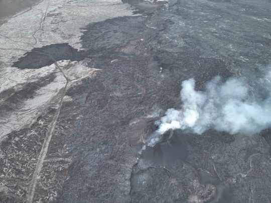 From the Civil Defense patrol flight on May 9. No lava splashes are visible in the crater, although smoke continues to pour out of it. (Photo: Civil Defense)
Satellite images do not show significant ground deformation witin the lava barriers by Grindavík
Updated 30. May at 14:00 UTC
- Significantly reduced volcanic activity
- Lava flow mainly in the area around Hagafell
- No explosive activity since yesterday
- GPS measurements suggest that the ground in the Svartsengi area subsided about 15 cm when magma flowed from there
- Possible gas pollution in South Iceland today and in the capital area this afternoon and tomorrow
- Gas distribution forecast available here
- Considerable uncertainty about the amount of gases from the eruption site. Real-time measurements of air quality available on the website of the EnvironmentAgency of Iceland
Since yesterday afternoon, activity on the eruptive fissure at the Sundhnúkur crater row has decreased significantly. The activity in the eruption has remained similar during last night and this morning and the volcanic tremor has been stable since late last evening. No explosive activity has been seen since yesterday afternoon when steam explosions occurred due to lava flowing into fissures and came into contact with groundwater at Hagafell. The activity is greatest close to the crater which was active for the longest time of the eruption that started on 16 March.
Yesterday afternoon a measurement flight over the eruption site with staff from the photogrammetry team of the Icelandic Institute of Natural History and the National Land Survey of Iceland. Aerial photography conditions were challenging as the eruption plume lay over part of the lava field formed at the eruption's beginning. The data collected during the aerial survey is being further processed, along with satellite images, to gain a clearer picture of the rate of lava discharge during the first few hours of the eruption. The accompanying map shows the roughly estimated outlines of the lava field as it was around 5 PM yesterday, or when the eruption had lasted for about four hours. The location of the eruption fissure is also indicated with red dashed lines.
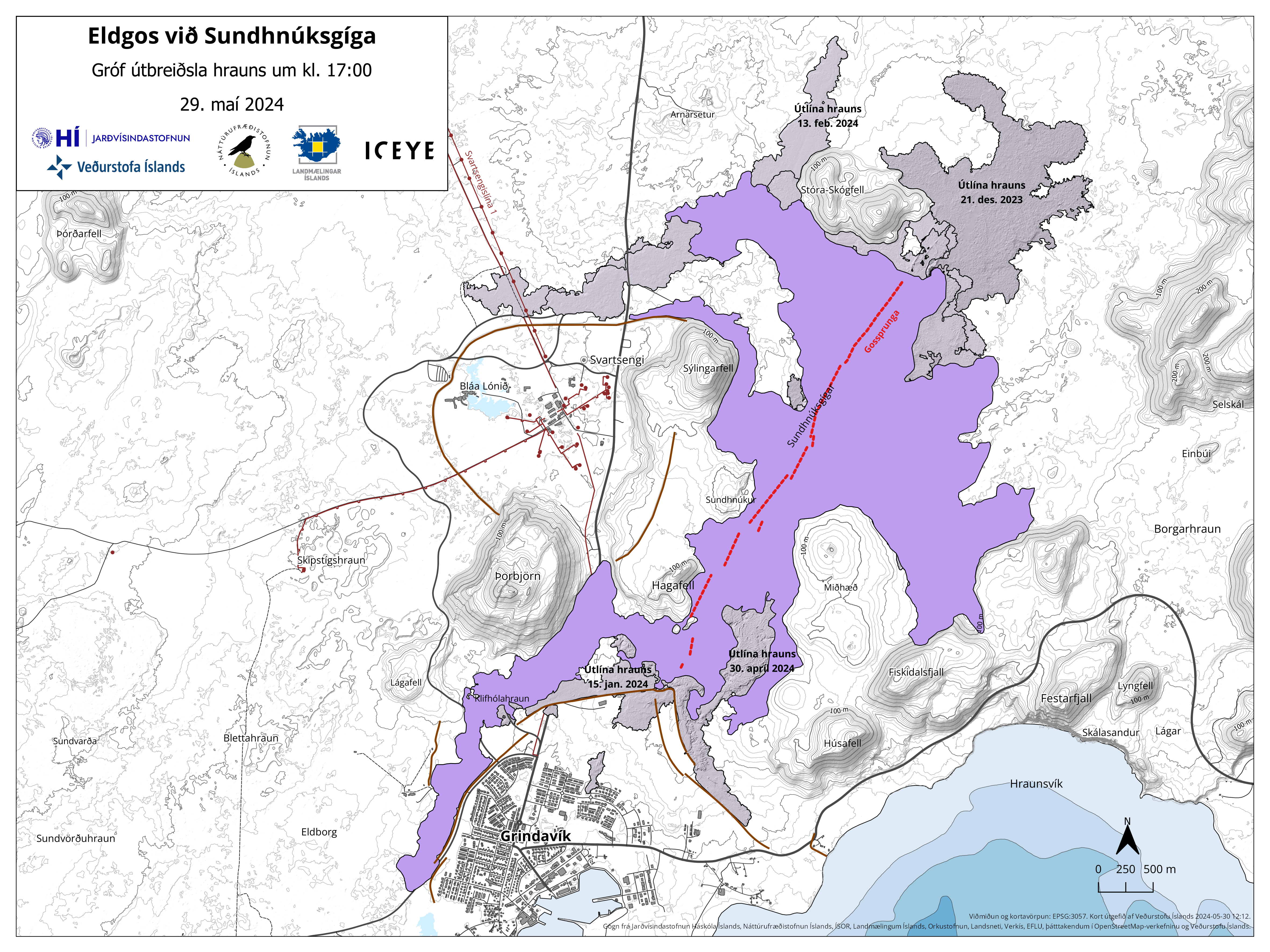 (Click on the map to see it larger)
GNSS data shows 15 cm deflation in Svartsengi area after the dike propagation
Satellite images taken early this morning, May 30, do not show significant movement on cracks within the town of Grindavík. Real-time deformation measurements also indicate that no significant deformation has been measured there since last night.
GNSS measurements show 15 cm deflation in Svartsengi after the dike propagation from there to the Sundhnúksgígar crater row. The dike that has formed and is now feeding the eruption extends from Mt. Stóra-Skógfell to Mt. Hagafell. It is estimated that about 15 million cubic meters of magma have already left the magma accumulation under Svartsengi.
Measurements and deformation data that will be available in the coming days will provide more information about the development of magma accumulation under Svartsengi and the possible evolution of the eruption. The Meteorological Office continues to monitor the area and observe the event's progression.
Gas Dispersion Forecast
The weather forecast for today (Thursday) predicts a westerly wind, with gas pollution expected to move eastwards, potentially being noticed in Ölfus and other parts of South Iceland. A more southwesterly wind is expected later in the day and continuing into tomorrow (Friday). This will cause the gas pollution to move northeast and could be detected in the capital area. There is considerable uncertainty regarding the amount of gas emissions from the eruption sites. You can follow the gas dispersion forecast and real-time measurements of various gases on the website loftgaedi.is.
The Meteorological Office has received reports of volcanic haze in many parts of the country, as well as being measured on the Environment Agency's monitoring instrument in Húsavík, north Iceland. According to the gas dispersion forecast, a large part of the country may experience volcanic haze today. Volcanic haze consists of sulfur particles (SO4) formed due to chemical reactions between the eruption plume and oxygen in the atmosphere. This process accelerates when air temperature is higher and the sun is shining, as was the case yesterday when the eruption began. These sulfur particles are not detected by SO2 gas meters but are visible as a gray-blue haze when a certain concentration is reached. An increase in fine particulate matter (PM1 and PM2.5) can indicate the presence of SO4. The values measured today are not above any health thresholds, but you can monitor the Environment Agency's air quality meters.
- CategoriesEdited | All Content | Disasters | Earthquakes | Volcanos | Science | Europe | Atlantic Ocean | News | News -- WNT Selected
- CreatedThursday, May 30, 2024
- Last modifiedFriday, June 07, 2024
SUBSCRIBE
Sign up for our weekly newsletter and World News Trust project updates.

World Desk Activities

www.imf.org/en/News/Podcasts/All-Podcasts/2024/05/…
en.vedur.is/about-imo/news/volcanic-unrest-grindav…


www.sciencealert.com/shift-in-indias-vulture-popul…
Shift in India's Vulture Population Linked to Half a Million Human Deaths : ScienceAlert
A cattle painkiller introduced in the 1990s led to the unexpected crash of India's vulture populations, which still haven't recovered to their former glory.

Tad author feed item to community feed
Latest Stories


Electronic Frontier Foundation
- Digital Apartheid in Gaza: Unjust Content Moderation at the Request of Israel’s Cyber Unit July 26, 2024
- Electronic Frontier Foundation to Present Annual EFF Awards to Carolina Botero, Connecting Humanity, and 404 Media July 25, 2024
- Briefing: Negotiating States Must Address Human Rights Risks in the Proposed UN Surveillance Treaty July 24, 2024
- Journalists Sue Massachusetts TV Corporation Over Bogus YouTube Takedown Demands July 24, 2024
The Conversation
- Vale Ray Lawler: the playwright who changed the sound of Australian theatre
- Magnificent and humbling: the Paris opening ceremony was a tribute to witnessing superhuman feats of the extraordinary
- How collaboration from across Canada, and the world, is helping fight the Alberta wildfires
- Paris Olympics: Canada’s soccer drone scandal highlights the need for ethics education
The Intercept
- Honduras, 15 Years After the Coup: An Interview With Ousted President Manuel Zelaya July 26, 2024
- Google Planned to Sponsor IDF Conference That Now Denies Google Was Sponsor July 25, 2024
- Deputy Accused of Killing Sonya Massey Was Discharged From Army for Serious Misconduct July 25, 2024
- U.S. Has Never Apologized to Somali Drone Strike Victims — Even When It Admitted to Killing Civilians July 25, 2024
VTDigger
- Waterbury residents looked to FEMA buyouts after last year’s floods. They’ve heard nothing for months July 26, 2024
- At a quiet Craftsbury pond, rowers become Olympians July 26, 2024
- UVM Medical Center wins approval to buy Fanny Allen Campus July 26, 2024
- Landslides and slurries have damaged homes, roads and driveways after this month’s flood July 26, 2024
