
Iceland Volcano: Increased Likelihood Of Volcanic Eruption In Coming Days -- Iceland Met Office
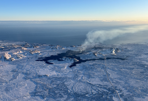 Lava from the eruption 8 Feb. 2024. Photo: Birgir Vilhelm Óskarsson/The Icelandic Institute of Natural History.
Activity has continued at a constant rate
Information is updated regularly here and on X (Formerly known as Twitter).
Updated 29 Feb. at 12:30 UTC
- An eruption could start with very little warning time, even less than 30 minutes.
- The eruption location is most likely in the area between Mt. Stóra-Skógfell and Mt. Hagafell.
- The hazard assessment does not account for weather conditions or other factors that may affect the risk of being within the hazard zones.
- A dike intrusion may occur without resulting in a volcanic eruption.
Model calculations suggest that as of today, about 8.5-9 million cubic metres of magma has accumulated beneath Svartsengi. The rate of inflation has been fairly constant for the past days. In previous developments, the rate of inflation has decreased shortly before an eruption starts.
According to model calculations, approximately 0.5 million cubic metres of magma is accumulated in the Svartsengi reservoir every 24 hours.
Considering precursors of previous volcanic eruptions in the Sundhnúkar crater row, the likelihood of a volcanic eruption increases once the volume of magma reaches 8 – 13 million cubic metres. If magma accumulation continues at the same rate, the amount should reach the upper limit next week.
There remains an increased likelihood of a volcanic eruption in the coming days. The most likely scenario is that a volcanic fissure opens in the area between Mt. Stóra-Skógfell and Mt. Hagafell which could occur with a very short warning time.
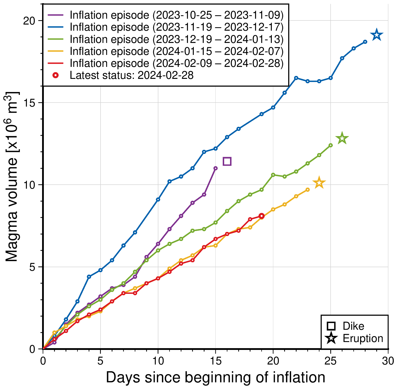 The graph shows a comparison of the volume of magma accumulated beneath Svartsengi before it propagates towards Sundhnúkur crater row. The status of the magma volume at 28 Feb. is indicated with red colour. The amount is derived through model calculations based on GPS data and is subject to uncertainties. Changes can vary from day to day, from being small to more prominent changes. The purple line shows the magma volume accumulated before the large diking event beneath Grindavík formed on 10 Nov. 2023.
A new hazard assessment map from IMO was published today and remains unchanged from the previous one. The hazard assessment map is valid until 5 March unless developments in activity call for a re-evaluation. Likely scenarios presented earlier this week also remain unchanged (see news from 26 Feb.).
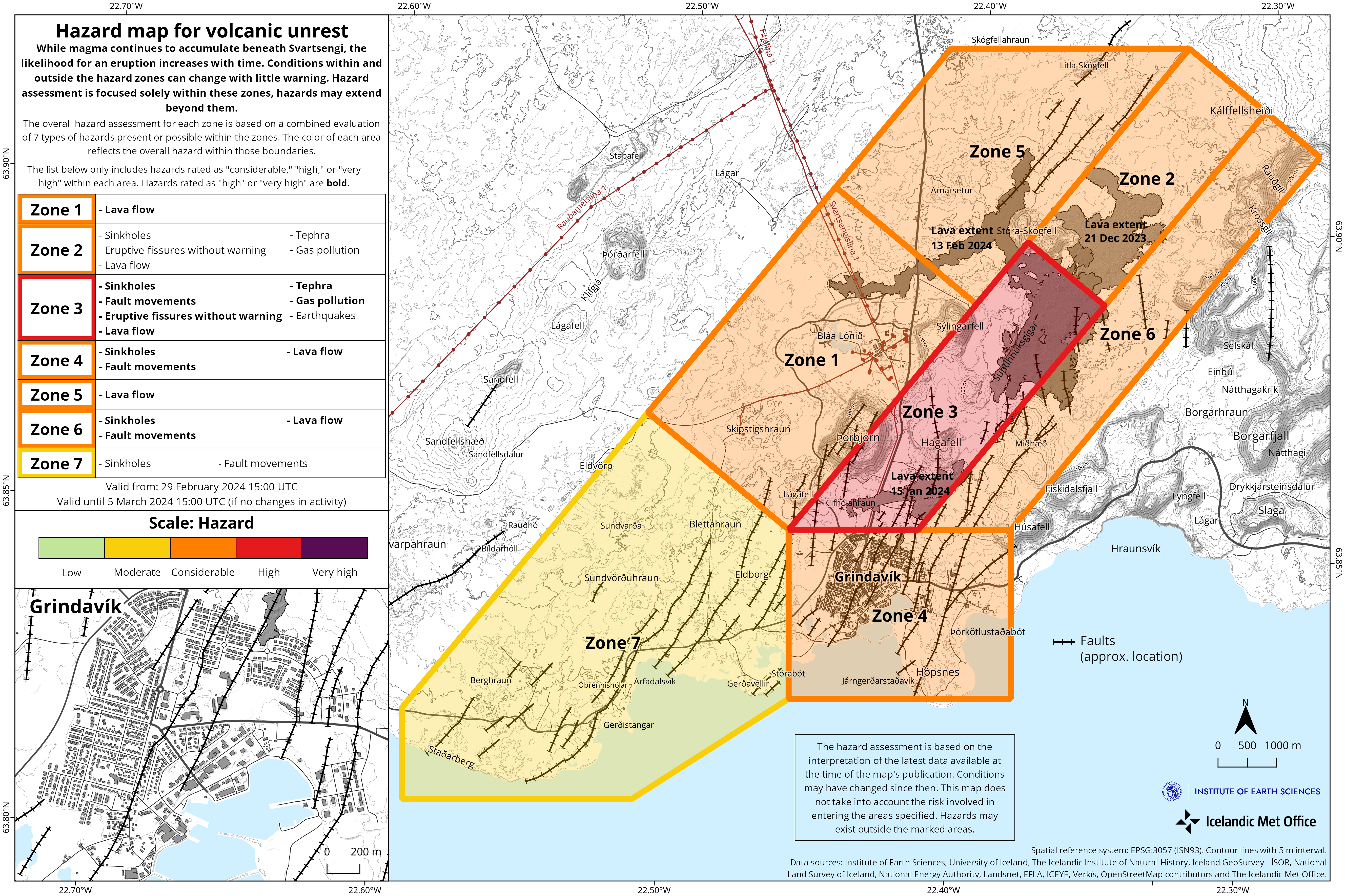 Please note that although the Iceland Meteorological Office has at this point not increased the hazard level in the unrest area, developments can occur very quickly and without warning. People entering the unrest area need to keep this in mind. The hazard assessment by IMO does not account for weather conditions or other factors which may affect the risk involved when being within a hazardous area. (Click the map to enlarge)
- CreatedThursday, February 29, 2024
- Last modifiedSaturday, March 02, 2024
SUBSCRIBE

World Desk Activities

phys.org/news/2024-05-composition-gut-microbiota-d…

Composition of gut microbiota could influence decision-making
The way we make decisions in a social context can be explained by psychological, social, and political factors. But what if other forces were at…
phys.org/news/2024-05-whales.html

Are we really about to talk to whales?
The past decade has seen an explosion of new research into some of the most fascinating sounds in the sea: the vocalizations of whales and…
phys.org/news/2024-05-black-teachers-lost-civil-ri…

How Black teachers lost when civil rights won in Brown v. Board
Brown v. Board of Education, the Supreme Court decision that desegregated public schools, stands in the collective national memory as a turning point in America's…
phys.org/news/2024-05-cancer-drug-pollution-global…

Cancer drug pollution is a growing global concern
As incidence of cancer increases globally, the use of cancer drugs is also growing at a rate of approximately 10 percent per year in developed…
phys.org/news/2024-05-summer-northern-hemisphere-h…

Summer 2023 was northern hemisphere's hottest for 2,000 years, tree rings show
The summer of 2023 was the warmest in the non-tropical areas of the northern hemisphere for 2,000 years, a new study has shown.
phys.org/news/2024-05-blooded-dinosaurs-roamed-ear…

When the first warm-blooded dinosaurs roamed Earth
Scientists once thought of dinosaurs as sluggish, cold-blooded creatures. Then research suggested that some could control their body temperature, but when and how that shift…
phys.org/news/2024-05-pyramids-built-lost-river-sc…

Pyramids built along long-lost river, scientists discover
Scientists have discovered a long-buried branch of the Nile river that once flowed alongside more than 30 pyramids in Egypt, potentially solving the mystery of…
phys.org/news/2024-05-danger-beauty-solar-storms.h…

'Danger behind the beauty': More solar storms could be heading our way
Tourists normally have to pay big money and brave cold climates for a chance to see an aurora, but last weekend many people around the…
techxplore.com/news/2024-05-terminal-diode-wireles…
A promising three-terminal diode for wireless communication and optically driven computing
Two-terminal devices are electronic components connected to electrical circuits via two electrical terminals. Although these components are the key building blocks of most existing devices,…
medicalxpress.com/news/2024-05-covid-vaccinations-…

Repeat COVID-19 vaccinations elicit antibodies that neutralize variants, other viruses
The COVID-19 pandemic is over, but the virus that caused it is still here, sending thousands of people to the hospital each week and spinning…
Latest Stories


Electronic Frontier Foundation
- The Alaska Supreme Court Takes Aerial Surveillance’s Threat to Privacy Seriously, Other Courts Should Too May 29, 2024
- Don't Let the Sun Go Down on Section 230 | EFFector 36.7 May 29, 2024
- A Wider View on TunnelVision and VPN Advice May 29, 2024
- EFF Submission to the Oversight Board on Posts That Include “From the River to the Sea” May 28, 2024
The Intercept
- He Made a PowerPoint on Mothers Starving in Gaza. Then He Lost His Government Job. May 31, 2024
- Columbia Coincidentally Rewrites Disciplinary Rules Just in Time to Screw Over Student Protesters May 31, 2024
- The Little-Known Reason Counties Keep Building Bigger Jails: Architecture Firms May 31, 2024
- These Convictions Thwart Trump’s Plan to Pardon Himself May 30, 2024
VTDigger
- ‘A sense of urgency’: Sen. Bernie Sanders pushes Vermont health care players on high costs May 31, 2024
- I-89 study focuses on South Burlington exit May 31, 2024
- Former St. Albans police officer permanently banned from police work in Vermont May 31, 2024
- Bear euthanized in Underhill displayed ‘exceptionally rare’ predatory behavior May 31, 2024
