
Iceland Volcano: Magma Continues To Accumulate Under Svartsengi -- Iceland Met Office
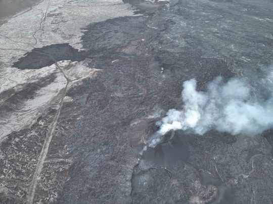 From the Civil Defense patrol flight on May 9. No lava splashes are visible in the crater, although smoke continues to pour out of it. (Photo: Civil Defense)
Preparations necessary for scenarios other than a volcanic eruption on the Sundhnúkur crater row
Updated 21. May at 17:30 UTC
Magma accumulation beneath Svartsengi continues at a stable rate
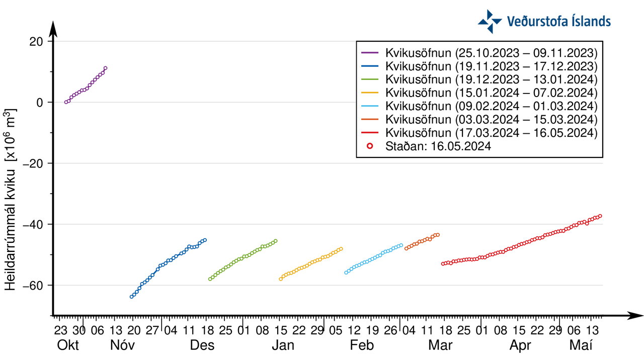
About 17 million m3 have been recharged into the magma accumulation zone since the onset of the last eruption (16 March)
Still increased likelihood of another dike propagation and an eruption
Precursory time prior to an eruption could be short
Around 200 earthquakes were detected in the unrest area during last weekend, most of them below M1.0. This is like the seismicity during last week when around 40 to 80 earthquakes were measured each day. Most of the earthquakes are located either in the area between Mt. Stóra-Skógfell and Mt. Hagafell or south of Mt. Þorbjörn.
Magma accumulation continues beneath the Svartsengi region and uplift also continues at a steady rate there. Minor changes in rate can be seen between days on the following graphs but overall, the trend continues at a steady rate. At this point it is still assumed that there is increased likelihood of a dike propagation and/or an eruption at the Sundhnúksgígar crater row.
Last news update reported increased micro seismicity over the last weeks in the area south of Mt. Þorbjörn and west of Grindavík. It was also mentioned that it would be possible that magma might find its way through weaknesses in the crust there. At this point, this scenario is considered very unlikely. That interpretation is based on new geodetic modelling and other data discussed at a scientific meeting yesterday, 21 May.
This gradual increase in seismicity is probably a sign of stress release in and around the dike intrusion at the Sundhnúksgígar crater row due to increased pressure in the magma accumulation zone beneath Svartsengi.
The most likely scenario is still considered to be a dike propagation and/or eruption at the Sundhnúksgígar crater row.
HS Orka monitors pressure changes in boreholes in the Svartsengi region. Sudden change in pressure has been one of the precursory signals seen prior to last dike propagations and eruptions. It has previously been reported that the signs of a new dike propagation would be localized seismic swarm, changes in the rate of deformation and pressure changes in boreholes. Minor pressure fluctuations were observed yesterday in a borehole in the Svartsengi region, but there was no significant increase in seismicity or deformation at the same time. Therefore, it was not assessed that the pressure fluctuations were a sign of a dike propagation.
Updated 17. May at 17:00 UTC
Magma accumulation beneath Svartsengi remains stable.
About 16 million cubic meters of magma have been added to the magma reservoir since 16 March.
Continued increased probability of another dyke propagation and another volcanic eruption.
Sundhnúkur crater row still the most likely location for a volcanic eruption.
Notice of an eruption could be very short.
Necessary to be prepared for other scenarios than a volcanic eruption on the Sundhnúkur crater row.
Around 50 earthquakes were detected in the area around the dyke intrusion yesterday, 16 May, most of them below M1.0. This is similar to the seismic activity that has been detected in recent days, but about 50 to 80 earthquakes have been measured per day, most of them occurring in two main areas, between Stóra-Skógfell and Hagafell and south of Þorbjörn.
Magma accumulation continues beneath Svartsengi and land uplift is ongoing at the same rate as before. Therefore, there is still an increased probability that in the coming days a new dyke intrusion and another volcanic eruption in the Sundhnúkur crater row could occur.
The last eruption in the Sundhnúkur crater row started on 16 March. In the 62 days that have passed since then, about 16 million cubic meters of magma have been added to the magma reservoir beneath Svartsengi. This is the longest period of magma accumulation since this scenario began at the end of October 2023.
Updated hazard assessment and possible scenarios
 The Icelandic Meteorological Office has published an updated hazard assessment map that is valid until 21 May barring any developments. The hazard of gas pollution in connection with an increased likelihood of another volcanic eruption is now considered high in area 7 but was previously considerable. Due to the change, the overall hazard in the area is now assessed as considerable (organge) but was previously moderate (yellow). Hazard due to gas pollution in other areas is unchanged from last week and is assessed as considerable. Due to increased microseismicity in area 4 the hazard of earthquakes has been raised.
IMO has updated the scenarios that are considered most likely.
Scenario 1 Volcanic eruption between Sýlingarfell and Stóra-Skógfell (Central part of zone 3 on hazard assessment map). Similar location as where the eruptions started on December 18 2023, February 8 and March 16 2024.
Probable precursors are localized, small seismic swarm between Stóra-Skógfell and Sýlingarfell, acceleration of deformation and pressure changes in boreholes in the area.
Very short notice (less than 30 minutes), even no notice due crust already being fractured.
Lava could reach Grindavíkurvegur in 2 to 4 hours.
Scenario 2 – Volcanic eruption south or southwest of Hagafell (Southernmost part of zone 3 on the hazard assessment map). Similar location as where the eruption started on January 14, 2024.
Probable precursors are a small seismic swarm that starts near Stóra-Skógfell or Sýlingarfell and moves south, acceleration of deformation and pressure changes in boreholes in the area.
The notice of an eruption in this zone would probably be longer than in scenario 1, but is is uncertain how much longer.
Lava could reach the barriers by Grindavík in about 1 hour.
A dyke intrusion extending south of Hagafell will probably cause significant fissure movements in Grindavík.
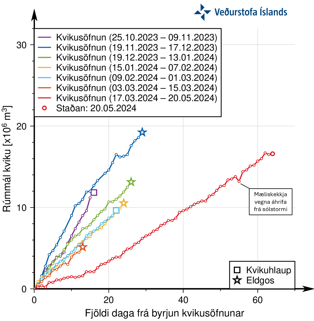
The total amount of magma in the magma reservoir beneath Svartsengi has never been more than before 10 Nov. 2023. Other scenarios need to be considered if magma accumulation continues without magma propagation or volcanic eruption.
Hitherto, the amount of magma that has been added to the magma reservoir between magma propagations or eruptions has been considered. In the context of increasing magma pressure in the magma reservoir beneath Svartsengi, it is necessary to consider the total amount of magma estimated to be present.
Between 25 Oct. and 10 Nov. 2023, more than 10 million m3 of magma accumulated beneath Svartsengi. It is estimated that about 80 million m3 of magma propagated from the magma reservoir during the formation of a 15 km long dyke intrusion on 10 Nov.. It can therefore be assumed that about 70 million m3 of magma was present in the magma reservoir beneath Svartsengi at that point. Magma accumulation has continued uninterrupted since then and magma has outflowed at least five times from Svartsengi to the Sundhnúksgígar crater row. Four of these five times have resulted in an eruption.
Each magma propagation or volcanic eruption has not exhausted the magma accumulation area, and therefore the initial status of magma accumulation beneath Svartsengi has varied in each cycle after November 2023, as shown in the figure below.
Caption: Graph showing the development of magma accumulation and the estimated total amount of magma in the magma reservoir beneath Svartsengi since Oct. 25. Each magma propagation did not exhaust the reservoir, and therefore the starting status of accumulation beneath Svartsengi will vary in each cycle after November 2023. The graph shows that the total amount of magma has never been higher since the forming of the 15 km long dyke on Nov. 10.
There are some similarities between this sequence of events in the Sundhnúkur crater row and the one that occurred in the Krafla Fires that started in 1975, Over 10-year period, there were 20 magma propagations, 9 of which ended in an eruption. During the Krafla Fires, the propagations all fed into the same dyke intrusion, but varied in size. Experience from the Krafla Fires suggests that as the number of magma propagations increases, more pressure is needed to trigger them. Therefore, it must be considered likely that magma will flow again from the magma reservoir beneath Svartsengi into the Sundhnúkur crater row.
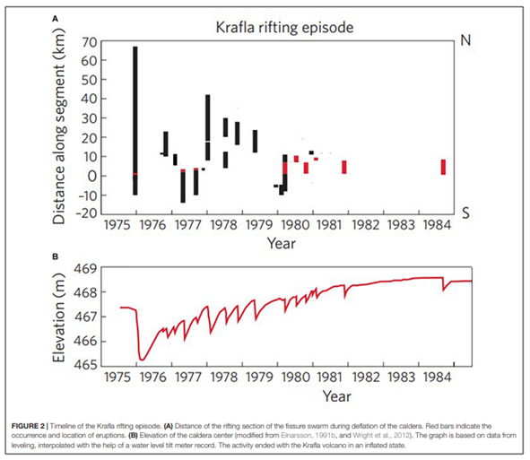
Caption: Figures showing the correlation between the formation of a dyke intrusion and the land elevation in the middle of the Krafla caldera. The lower figure shows the elevation of the measurement point within the caldera, while the upper figure shows the distance (km) of events from the Krafla caldera in each event, with red color representing a volcanic eruption (Páll Einarsson and Bryndís Brandsdóttir, 2021).
The total amount of magma in the reservoir beneath Svartsengi has never been higher since the 15 km dyke instrusion formed on 10 Nov.. As more time passes without a new magma propagation into the Sundhnúkur crater row, the likelihood of magma finding its way to other areas where weakness is found in the Earth's crust increases.
Micro-seismic activity has been ongoing for the past few weeks in the area south of Þorbjörn, in the large rift valley by Grindavík. In this area, there are weaknesses in the Earth's crust and thus magma could reach the surface there. The fact that magma flows from the magma reservoir to the area south of Þorbjörn is at this point in time a less likely scenario than the ones mentioned above. Therefore, this scenario is not taken into account in the updated hazard assessment. The Icelandic Meteorological Office will collect and process data over the next few days to shed a better light on this possibility.
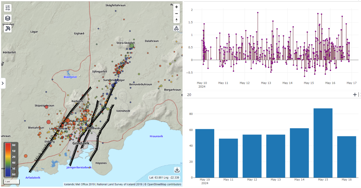
The map shows earthquakes from 10-16 May. The upper graph shows the magnitude of the earthquakes and the lower graph show the number of earthquakes each day for the same period.
- CategoriesEdited | All Content | Disasters | Earthquakes | Volcanos | Government | Science | Europe | Atlantic Ocean | News -- WNT Selected
- CreatedTuesday, May 21, 2024
- Last modifiedFriday, June 07, 2024
SUBSCRIBE
Sign up for our weekly newsletter and World News Trust project updates.

World Desk Activities

www.imf.org/en/News/Podcasts/All-Podcasts/2024/05/…
en.vedur.is/about-imo/news/volcanic-unrest-grindav…


www.sciencealert.com/shift-in-indias-vulture-popul…
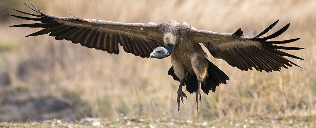
Shift in India's Vulture Population Linked to Half a Million Human Deaths : ScienceAlert
A cattle painkiller introduced in the 1990s led to the unexpected crash of India's vulture populations, which still haven't recovered to their former glory.

Tad author feed item to community feed
Latest Stories


Electronic Frontier Foundation
- Digital Apartheid in Gaza: Unjust Content Moderation at the Request of Israel’s Cyber Unit July 26, 2024
- Electronic Frontier Foundation to Present Annual EFF Awards to Carolina Botero, Connecting Humanity, and 404 Media July 25, 2024
- Briefing: Negotiating States Must Address Human Rights Risks in the Proposed UN Surveillance Treaty July 24, 2024
- Journalists Sue Massachusetts TV Corporation Over Bogus YouTube Takedown Demands July 24, 2024
The Conversation
- Vale Ray Lawler: the playwright who changed the sound of Australian theatre
- Magnificent and humbling: the Paris opening ceremony was a tribute to witnessing superhuman feats of the extraordinary
- How collaboration from across Canada, and the world, is helping fight the Alberta wildfires
- Paris Olympics: Canada’s soccer drone scandal highlights the need for ethics education
The Intercept
- Honduras, 15 Years After the Coup: An Interview With Ousted President Manuel Zelaya July 26, 2024
- Google Planned to Sponsor IDF Conference That Now Denies Google Was Sponsor July 25, 2024
- Deputy Accused of Killing Sonya Massey Was Discharged From Army for Serious Misconduct July 25, 2024
- U.S. Has Never Apologized to Somali Drone Strike Victims — Even When It Admitted to Killing Civilians July 25, 2024
VTDigger
- Waterbury residents looked to FEMA buyouts after last year’s floods. They’ve heard nothing for months July 26, 2024
- At a quiet Craftsbury pond, rowers become Olympians July 26, 2024
- UVM Medical Center wins approval to buy Fanny Allen Campus July 26, 2024
- Landslides and slurries have damaged homes, roads and driveways after this month’s flood July 26, 2024
