
Iceland Volcano: Ground Uplift Continues In The Svartsengi Area -- Iceland Met Office
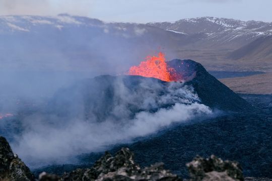 Volcano eruption at Sundhnúkur. Photo taken 10. April 2024 by Jón Bjarni Friðriksson/IMO.
A strong geomagnetic storm impacted GNSS measurements over the weekend
Updated 13. May at 15:00 UTC
There is an increased likelihood of a new dike intrusion and another eruption in the coming days.
The most likely location for a new eruption is the Sundhnúk crater row.
Warning signs preceding an eruption could be very short.
Ground uplift continues in the Svartsengi area at the same rate as previously observed. Since March 16th, when the last volcanic eruption began, ground uplift has reached approximately 20 cm at the GNSS station in Svartsengi. Magma accumulation continues in the reservoir, and the likelihood of a new dike intrusion and a new eruption continues to increase.
In the previous dike intrusions and eruptions over the past several months, approximately 8 to 13 million cubic meters of magma were recharged to the reservoir beneath Svartsengi between events before the magma migrated to the surface towards the Sundhnúk crater row. Now, the volume of magma added since March 16th has exceeded the previously observed upper limit.
Seismic activity is relatively stable between days. In the last week, approximately 50 to 80 earthquakes were recorded per day, mostly occurring in the areas between Stóra-Skógfell and Hagafell and south of Þorbjörn. Most of the earthquakes have magnitudes below 1.0, but isolated earthquakes with magnitudes close to 2.0 have been recorded. Signs of a new dike intrusion are expected to be similar to those previously observed, such as localized seismic activity in and around the dike, fast ground deformation, and pressure changes in nearby boreholes.
The Icelandic Meteorological Office continues its 24-hour surveillance of the area. New eruptive fissures could open in the area between Stóra-Skógfell and Hagafell, and signs of magma migrating towards the surface would likely resemble the initial phases of other recent eruptions in the area. This could occur with little to no warning.
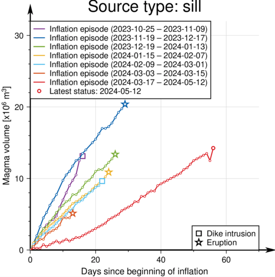 The graph shows the estimated volume of magma that has recharged beneath the Svartsengi area between the series of volcanic eruptions and dike intrusions that began in November 2023. Note that a geomagnetic storm over the weekend disturbed the measurements. (See discussion below.)
Disturbance in GNSS measurements due to the geomagnetic storm
Land uplift is calculated by measuring the change in the amount of time it takes for a signal to travel from satellites orbiting the earth to GNSS receivers on the ground. If the duration of time for the signal to travel between the satellite and the receiver decreases, it indicates that the land has risen.
Over the weekend, one of the most powerful geomagnetic storms in recent years occurred when solar winds from large sunspots on the Sun hit the Earth. The last geomagnetic storm of a similar magnitude occurred on October 30, 2003.
Strong solar winds send charged particles into the Earth's magnetic field, affecting signal transmissions between GNSS receivers on the ground and satellites. This interference affects the travel time of the signal, causing deformation measurements that could be interpreted as a slowdown in magma accumulation rate. However, this is not the case, as a new data point calculated this morning is at a "normal" location compared to previous measurements. (See graph above).
Disturbances due to geomagnetic storms do not affect the Icelandic Meteorological Office's ability to provide warnings of imminent dike intrusions or eruptions.
Updated 10. May at 18:00 UTC
There is an increased likelihood of a new dike intrusion and another eruption in the coming days.
The most likely location for a new eruption is the Sundhnúk crater row.
Warning signs preceding an eruption could be very brief.
An updated hazard assessment map has been issued.
The trend of land rise at Svartsengi has remained relatively stable since the most recent volcanic eruption ended, with magma accumulation continuing at a similar rate. As of today, it is estimated that approximately 14 million cubic meters of magma has been added to the magma chamber since the eruption began on March 16th.
In the dike intrusions and eruptions over the past few months, approximately 8 to 13 million cubic meters of magma was added to the chamber beneath Svartsengi before it exited the chamber and travelled towards the Sundhnúk crater row. Now, the amount of magma added has surpassed the previously observed upper limit. Observations from the Krafla eruptions can add context to this behavior, revealing that, as more dike intrusions occur, more pressure is required to initiate them. Therefore, it is likely that the magma chamber beneath Svartsengi will eventually feed another intrusion into the Sundhnúk crater row. However, there is uncertainty about when sufficient pressure will be reached to initiate a new dike intrusion and potentially an eruption if magma reaches the surface.
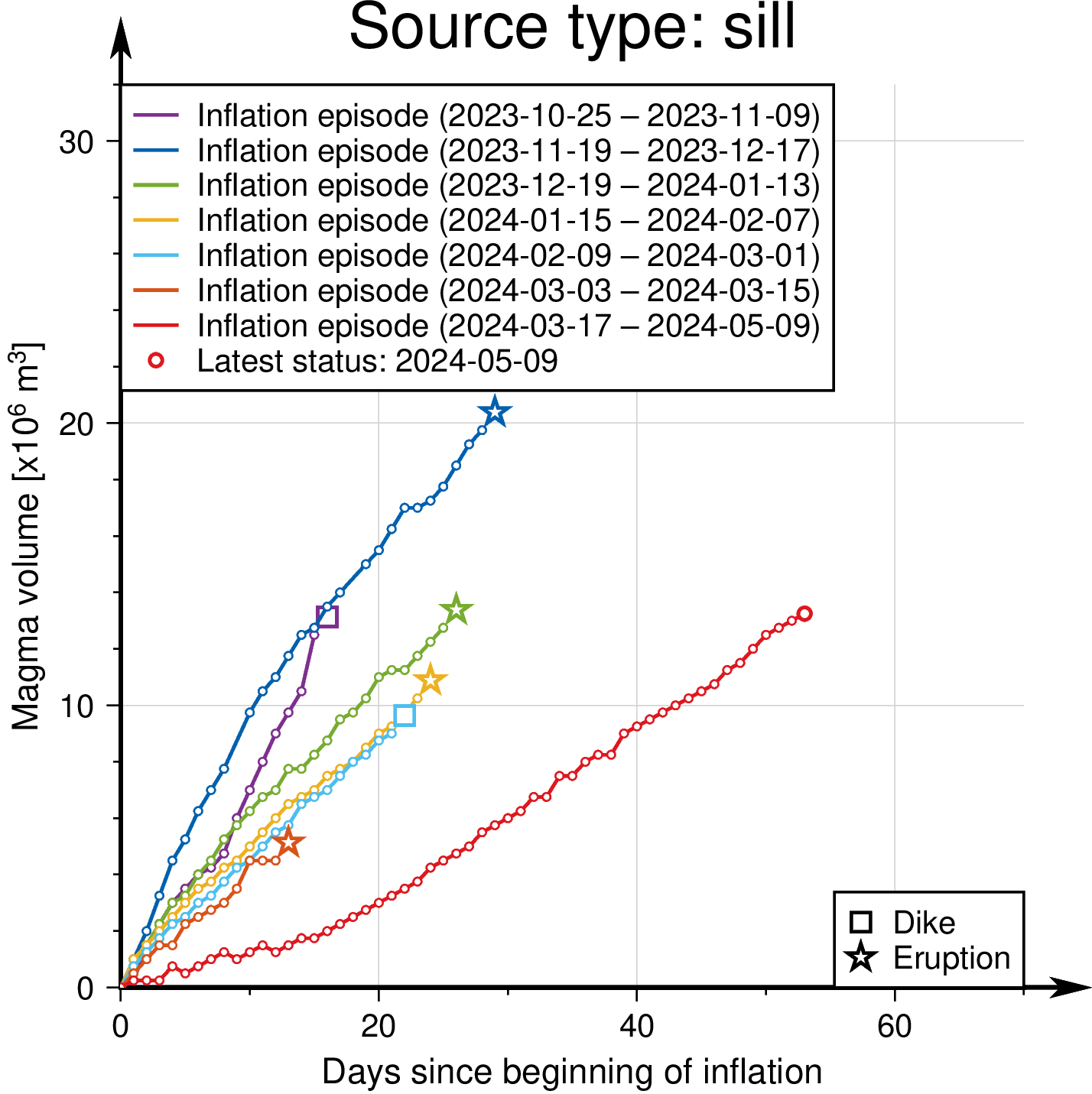 Graph showing the estimated amount of magma that has accumulated beneath Svartsengi between the eruptions and dike intrusions that have occurred on Reykjanes since November 2023.
The Icelandic Meteorological Office continues its 24-hour surveillance of the area to closely monitor the activity. New eruptive fissures could open in the area between Stóra-Skógfell and Hagafell and may resemble the initial phases of other recent eruptions in the area. This could happen with little to no warning. Signs of a new dike intrusion would be similar to those previously observed: localized earthquakes in and around the dike, accelerated deformation, and pressure changes in nearby boreholes.
Increased seismic activity has been recorded at the Sundhnúk crater row in recent days. This increase in seismic activity is likely a sign that stress is being released in and around the recent eruption site on the Sundhnúk crater row due to increased pressure in the magma chamber beneath Svartsengi.
Last night, the Icelandic Meteorological Office's 24-hour surveillance team detected an increase in localized seismic activity south of Stóra-Skógfell, in a similar location to where previous eruptions have started. Deformation and pressure measurements, which would indicate a dike intrusion, did not exhibit significant changes. The activity persisted for a relatively short duration, but it cannot be ruled out that a small amount of magma may have been injected there.
Dangerous to travel near the Sundhnúk crater row
The Icelandic Meteorological Office has issued an updated hazard assessment. The termination of the last eruption has caused updates in several areas, but the current hazard assessment reflects increased chances of a new dike intrusion and possible eruption.
As the crust between Stóra-Skógfell and Hagafell is heavily fractured, magma is likely to find a clear path to the surface without significant resistance, and therefore, substantial seismic activity may not accompany magma migration through the crust. Therefore, warning times before a new eruption could be very brief or nonexistent, so it is important to exercise extreme caution when travelling to area 3, defined on the Icelandic Meteorological Office's hazard map. The new risk assessment is valid until May 14th, unless the situation changes.
 Click to enlarge
- CategoriesEdited | All Content | Disasters | Earthquakes | Volcanos | Government | Science | Europe | Atlantic Ocean | News | News -- WNT Selected
- CreatedMonday, May 13, 2024
- Last modifiedMonday, May 20, 2024
SUBSCRIBE
Sign up for our weekly newsletter and World News Trust project updates.

World Desk Activities

www.imf.org/en/News/Podcasts/All-Podcasts/2024/05/…
en.vedur.is/about-imo/news/volcanic-unrest-grindav…


www.sciencealert.com/shift-in-indias-vulture-popul…

Shift in India's Vulture Population Linked to Half a Million Human Deaths : ScienceAlert
A cattle painkiller introduced in the 1990s led to the unexpected crash of India's vulture populations, which still haven't recovered to their former glory.

Tad author feed item to community feed
Latest Stories


Electronic Frontier Foundation
- Digital Apartheid in Gaza: Unjust Content Moderation at the Request of Israel’s Cyber Unit July 26, 2024
- Electronic Frontier Foundation to Present Annual EFF Awards to Carolina Botero, Connecting Humanity, and 404 Media July 25, 2024
- Briefing: Negotiating States Must Address Human Rights Risks in the Proposed UN Surveillance Treaty July 24, 2024
- Journalists Sue Massachusetts TV Corporation Over Bogus YouTube Takedown Demands July 24, 2024
The Conversation
- Vale Ray Lawler: the playwright who changed the sound of Australian theatre
- Magnificent and humbling: the Paris opening ceremony was a tribute to witnessing superhuman feats of the extraordinary
- How collaboration from across Canada, and the world, is helping fight the Alberta wildfires
- Paris Olympics: Canada’s soccer drone scandal highlights the need for ethics education
The Intercept
- Honduras, 15 Years After the Coup: An Interview With Ousted President Manuel Zelaya July 26, 2024
- Google Planned to Sponsor IDF Conference That Now Denies Google Was Sponsor July 25, 2024
- Deputy Accused of Killing Sonya Massey Was Discharged From Army for Serious Misconduct July 25, 2024
- U.S. Has Never Apologized to Somali Drone Strike Victims — Even When It Admitted to Killing Civilians July 25, 2024
VTDigger
- Waterbury residents looked to FEMA buyouts after last year’s floods. They’ve heard nothing for months July 26, 2024
- At a quiet Craftsbury pond, rowers become Olympians July 26, 2024
- UVM Medical Center wins approval to buy Fanny Allen Campus July 26, 2024
- Landslides and slurries have damaged homes, roads and driveways after this month’s flood July 26, 2024
