
Iceland Volcano: No Visible Eruptive Activity -- Iceland Met Office
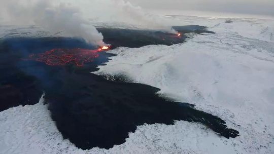 Photo taken on Dec. 19 at 15:00 UTC and shows the three fountains, the most powerful being from two of them. At the front of the picture is the lava tongue that stretches to the west just north of Stóra-Scógfell. (Photo: National Police Chief's Special Squad)
However, there may be lava flow in closed channels. The earthquake activity continues to decrease
Information updated regularly here and on X (Formerly known as Twitter).
Updated 21 December at 12:55 UTC
Scientists who flew over the eruption site this morning confirm that no eruptive activity is visible and that lava flow from the craters seems to have ceased. Glowing is still visible in the lava field, possibly within closed channels. This was also confirmed by an Elfu staff member in Sýlingarfell. The activity appears to have diminished late last night or very early this morning. However, it is still possible that lava is flowing in closed channels, so it is premature to declare the eruption over.
Earthquake activity has continued to decrease, and over the last 24 hours, approximately 70 minor earthquakes were measured over the magma conduits. The largest quake yesterday occurred at 14:27 and measured 1.4 in magnitude, while the largest since midnight last night was magnitude 1.9. Deformation measurements at Svartsengi show little movement, but measurements over the next few days will further clarify the situation there.
Gas dispersion, mainly due to the degassing of the lava field, will be southeastward and out to sea today. Tomorrow, with a slower northeast wind, the gas will travel southwest.
At this point, it is difficult to predict the continuation of the eruption, but scientists at the Meteorological Office are constantly assessing the latest data and continue to closely monitor the area.
Updated 20 December at 18:50 UTC
The eruption that began in the Sundhnúksgígar crater row on 18 December started with considerable force, and the warning period was short. About 90 minutes passed from the first signs of seismicity until the eruption began. The eruption occurred on the magma intrusion that formed on 10 November. The magma is sourced most likely from beneath Svartsengi, where the land has risen repeatedly since 2020.
In the last 24 hours, the highest activity in the eruption has remained around the middle of the fissure that opened on 18 December. Seismic activity has been relatively steady, and there have been little changes in deformation since the eruption began. Considering this, the Icelandic Meteorological Office (IMO) assesses that the likelihood of a new eruption forming without warning near Grindavík has decreased. Therefore, IMO has issued a new hazard assessment map that will take effect tomorrow, Thursday, 21 December at 7:00 UTC. The hazard assessment map is valid until 28 December. It should be noted that although the likelihood of vent formation within Area 4 has decreased, the hazard level in that area is nevertheless considered substantial. Even though the activity has decreased since the eruption began, the intensity of the eruption is still significant and comparable to eruptions at Fagradalsfjall. It has also been shown that the magma can reach the surface quickly, leaving little time to issue warnings.

Because of the volcanic eruption that began at Sundhnúksgígar crater row on 18 December, there is an increased likelihood of further vent openings on the original fissure. Based on the sudden onset of the eruption at Sundhnúksgígar, the warning time for new fissure openings could be very short.
Updated 20 December at 17:00 UTC
The vigor of the eruption continues to diminish. New images of the area show that currently, two craters are erupting. The most active today is the crater directly east of Sýlingarfell which is the southernmost of the craters that were active yesterday.
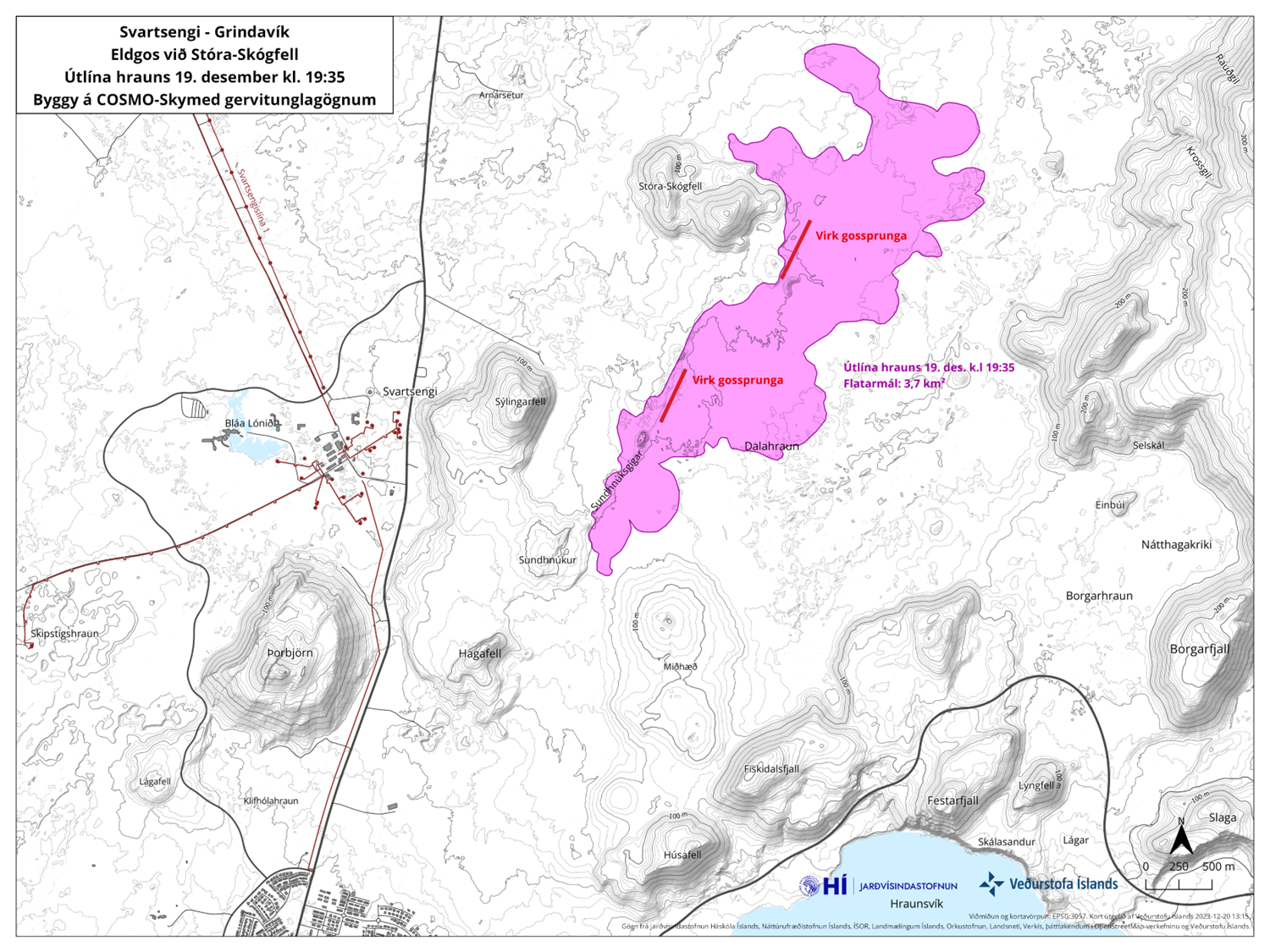
Lava continues to mostly flow east from the volcanic vents, but a lava tongue has also run west, north of Stóra-Skógfell. The southernmost edge of the lava does not appear to be advancing. Satellite images taken last night show that the lava field is about 3.7 square kilometers in size.
Wind will turn northwesterly tonight and tomorrow, and pollution will be transported southeastward and out to sea. The Icelandic Meteorological Office regularly issues gas pollution forecasts.
There has been a significant decrease in earthquake activity, and over the last 24 hours, about 80 small tremors have been measured over the magma conduits. The largest quake was 2.2 in magnitude at 10:55 am yesterday morning, and the largest since midnight is 1.2 in magnitude.
Updated 19 December at 18:30 UTC
The eruption continues to weaken. New aerial images of the area show that there are now three vents erupting southeast of Stóra-Skógfell, down from the previous five. The lava has mostly flowed east from the eruption site, but there is also a lava tongue flowing west from the region north of Stóra-Skógfell.
Since the eruption began, about 320 earthquakes have been measured over the magma channels. The largest earthquake, with a magnitude of 4.1, occurred at 23:25 on Monday. After midnight, seismic activity significantly decreased, and since 12:00 today, only 10 earthquakes have been recorded in the region. Following the eruption at Sundhnúksgíga, the land in Svartsengi subsided more than 5 cm. Previously, the land had risen there by about 35 cm since the formation of the magma channel on November 10. It is too early to determine if magma will continue to accumulate under Svartsengi and whether the land will start to rise again.
While the eruption continues at Sundhnúksgíga, there is an increased likelihood that more vents may open along the original fissure as well as further north or south. Looking back at the lead-up to the eruption reveals that there were approximately 90 minutes between the first indicators and the start of the eruption. Therefore, the warning time for new vent openings at Sundhnúk could be very short.
Updated 19 December at 14:30 UTC
The size of the volcanic eruption at Sundhnúksgígar continues to diminish. The lava flow is estimated to be about one-quarter of what it was at the beginning of the eruption on 18 December, and a third of the original fissure is active. The lava fountains are also lower than at the start of the eruption, reaching about 30 meters at their highest. These figures are based on visual estimates from a reconnaissance flight early on 19 December.
The development of the eruption is similar to recent eruptions at Fagradalsfjall, where the fissures are starting to contract and form individual eruption vents. Presently, there are about five eruption vents spread along the original fissure.
According to information from scientists who went on a second helicopter flight with the Icelandic Coast Guard at around 04:00 UTC today, the total length of the fissure eruption has not changed much from the beginning. There was little activity at the southern end of the fissure near Hagafell, and the majority of the lava flow is heading east towards Fagradalsfjall. Two streams reach west, both north of Stóra-Skógfell.
At the time of publication, the volcanic plume is drifting from the west and northwest. Gas pollution might be noticeable in Vestmannaeyjar today, but not elsewhere in populated areas. According to the weather forecast, gas pollution might be detected in the capital area late tonight or tomorrow morning.
A new hazard assessment map is being prepared, and it will be published later today.
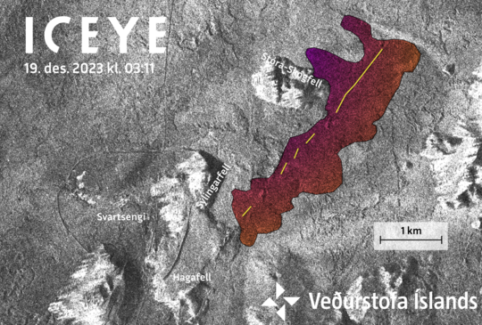
Amplitude image from an ICEYE satellite acquired at 03:11 this morning (19 Dec. 2023). Preliminary analysis of this image show the new eruptive fissure (yellow line) and lava flow (colored area). Notice that he dams built around Svartsengi are clearly visible.
(more)
- CategoriesEdited | All Content | Disasters | Environment | Earthquakes | Volcanos | Government | Science | Technology | North America | Europe | Atlantic Ocean | News -- WNT Selected
- CreatedThursday, December 21, 2023
- Last modifiedFriday, December 22, 2023
SUBSCRIBE
Sign up for our weekly newsletter and World News Trust project updates.

World Desk Activities

www.imf.org/en/News/Podcasts/All-Podcasts/2024/05/…
en.vedur.is/about-imo/news/volcanic-unrest-grindav…


www.sciencealert.com/shift-in-indias-vulture-popul…
Shift in India's Vulture Population Linked to Half a Million Human Deaths : ScienceAlert
A cattle painkiller introduced in the 1990s led to the unexpected crash of India's vulture populations, which still haven't recovered to their former glory.

Tad author feed item to community feed
Latest Stories


Electronic Frontier Foundation
- Digital Apartheid in Gaza: Unjust Content Moderation at the Request of Israel’s Cyber Unit July 26, 2024
- Electronic Frontier Foundation to Present Annual EFF Awards to Carolina Botero, Connecting Humanity, and 404 Media July 25, 2024
- Briefing: Negotiating States Must Address Human Rights Risks in the Proposed UN Surveillance Treaty July 24, 2024
- Journalists Sue Massachusetts TV Corporation Over Bogus YouTube Takedown Demands July 24, 2024
The Conversation
- Vale Ray Lawler: the playwright who changed the sound of Australian theatre
- Magnificent and humbling: the Paris opening ceremony was a tribute to witnessing superhuman feats of the extraordinary
- How collaboration from across Canada, and the world, is helping fight the Alberta wildfires
- Paris Olympics: Canada’s soccer drone scandal highlights the need for ethics education
The Intercept
- Honduras, 15 Years After the Coup: An Interview With Ousted President Manuel Zelaya July 26, 2024
- Google Planned to Sponsor IDF Conference That Now Denies Google Was Sponsor July 25, 2024
- Deputy Accused of Killing Sonya Massey Was Discharged From Army for Serious Misconduct July 25, 2024
- U.S. Has Never Apologized to Somali Drone Strike Victims — Even When It Admitted to Killing Civilians July 25, 2024
VTDigger
- Waterbury residents looked to FEMA buyouts after last year’s floods. They’ve heard nothing for months July 26, 2024
- At a quiet Craftsbury pond, rowers become Olympians July 26, 2024
- UVM Medical Center wins approval to buy Fanny Allen Campus July 26, 2024
- Landslides and slurries have damaged homes, roads and driveways after this month’s flood July 26, 2024
