
Iceland Volcano: No Signs Of Eruptive Activity -- Iceland Met Office
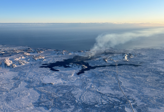 Lava from the eruption 8. February 2024. Photo: Birgir Vilhelm Óskarsson/The Icelandic Institute of Natural History.
Updated hazard assessment according to the development
Information is updated regularly here and on X (Formerly known as Twitter).
Updated 12. February at 16:00 UTC
The Iceland Meteorological Office has updated the hazard assessment according to the development of the eruptive activity. Changes have been made to the hazard assessment for some hazards within zones.
The overall hazard assessment for the area remains unchanged from the last map. There is still considered to be a sinkholes and fault movements area 4 (Grindavík).
 The hazard assessment map is valid until Thursday, 15 February, unless changes in activity calls for a re-evaluation. (Click on the map to make it larger)
Updated 12. February at 14:30 UTC
Inflation has started again at Svartsengi after having subsided following the eruption that started 8. February. The inflation rate is about 0.5-1.0 cm/day which is similar to the rates detected before the last eruptions. Magma thus continues to accumulate in the magma reservoir beneath Svartsengi. It is therefore highly likely that the cycle continues in a few weeks with another dyke propagation and a volcanic eruption.
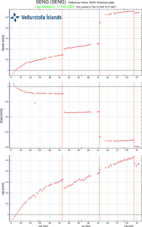 Time series from the GPS station Svartsengi (SENG) since 11th of November 2023 in the north, east and vertical directions (top, middle and bottom images, respectively). The bottom time series show land uplift in millimetres and yesterday's datapoint (11th of February) is shown with a green dot. The red vertical lines are timings of the last three eruptions (18th of December 2023, 14th of January 2024 and 8th of February 2024).
Since noon of 8. February, seismic activity in the area north of Grindavík has been minor, about 50 small earthquakes have been detected, all of which were around or less than M1.0. A small seismic swarm has been ongoing in the western parts of Mt. Fagradalsfjall with about 100 earthquakes detected, mostly M1 events or smaller. Minor swarms in the Fagradalsfjall area have occurred frequently for the past weeks, the depth of the earthquakes is at around 6-8 km.
- CategoriesEdited | All Content | Disasters | Earthquakes | Volcanos | Government | Science | Europe | Atlantic Ocean | News | News -- WNT Selected
- CreatedMonday, February 12, 2024
- Last modifiedFriday, February 16, 2024
SUBSCRIBE
Sign up for our weekly newsletter and World News Trust project updates.

World Desk Activities

www.imf.org/en/News/Podcasts/All-Podcasts/2024/05/…
en.vedur.is/about-imo/news/volcanic-unrest-grindav…


www.sciencealert.com/shift-in-indias-vulture-popul…

Shift in India's Vulture Population Linked to Half a Million Human Deaths : ScienceAlert
A cattle painkiller introduced in the 1990s led to the unexpected crash of India's vulture populations, which still haven't recovered to their former glory.

Tad author feed item to community feed
Latest Stories


Electronic Frontier Foundation
- Digital Apartheid in Gaza: Unjust Content Moderation at the Request of Israel’s Cyber Unit July 26, 2024
- Electronic Frontier Foundation to Present Annual EFF Awards to Carolina Botero, Connecting Humanity, and 404 Media July 25, 2024
- Briefing: Negotiating States Must Address Human Rights Risks in the Proposed UN Surveillance Treaty July 24, 2024
- Journalists Sue Massachusetts TV Corporation Over Bogus YouTube Takedown Demands July 24, 2024
The Conversation
- Vale Ray Lawler: the playwright who changed the sound of Australian theatre
- Magnificent and humbling: the Paris opening ceremony was a tribute to witnessing superhuman feats of the extraordinary
- How collaboration from across Canada, and the world, is helping fight the Alberta wildfires
- Paris Olympics: Canada’s soccer drone scandal highlights the need for ethics education
The Intercept
- Honduras, 15 Years After the Coup: An Interview With Ousted President Manuel Zelaya July 26, 2024
- Google Planned to Sponsor IDF Conference That Now Denies Google Was Sponsor July 25, 2024
- Deputy Accused of Killing Sonya Massey Was Discharged From Army for Serious Misconduct July 25, 2024
- U.S. Has Never Apologized to Somali Drone Strike Victims — Even When It Admitted to Killing Civilians July 25, 2024
VTDigger
- Waterbury residents looked to FEMA buyouts after last year’s floods. They’ve heard nothing for months July 26, 2024
- At a quiet Craftsbury pond, rowers become Olympians July 26, 2024
- UVM Medical Center wins approval to buy Fanny Allen Campus July 26, 2024
- Landslides and slurries have damaged homes, roads and driveways after this month’s flood July 26, 2024
