
Iceland Volcano: Magma Accumulation Beneath Svartsengi Continues -- Iceland Met Office
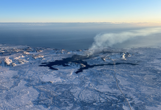 Lava from the eruption 8 Feb. 2024. Photo: Birgir Vilhelm Óskarsson/The Icelandic Institute of Natural History.
Model calculations suggest that -- by the end of February or early March -- magma accumulation will reach a level similar to that before the last eruption.
An updated hazard map has been published.
Information is updated regularly here and on X (Formerly known as Twitter).
Updated 15. February at 16:00 UTC
Land uplift at the Svartsengi area continues at similar trends and rates as those detected after dyke propagations from there.
Model calculations based on GPS data suggest that magma accumulation from the end of the eruption 9 Feb. until yesterday, 14 Feb., is about 2 million m3. It was estimated that when the eruption began on 8 Feb., about 10 million m3 of magma propagated from Svartsengi towards Sundhnúkur crater row.
If magma accumulation continues at the same rate, a total of 10 million m3 will accumulate by the end of February or early March, by which time the likelihood of dyke propagation and volcanic eruption will increase significantly. These model calculations are based on GPS data but will be updated when new satellite data comes in.
Seismic activity in the western parts of Mt. Fagradalsfjall continues with about 80 small earthquakes of magnitudes 1.5 or smaller detected since 12 Feb. The depth of the earthquakes under the western part of Mt. Fagradalsfjall is at 6-8 km. The area remains closely monitored but at the moment deformation data do not show signs of magma accumulation.
The Iceland Met Office has published an updated hazard map, valid until 22 Feb. unless developments call for a re-evaluation. The main changes are that likelihood of eruptive vents opening has decreased in all Zones. Likelihood of sinkholes and fault movements are still considered high in Zone 4 (Grindavík). Please note that the hazard zones are active, and changes can occur with short notice. Furthermore, hazards can be present outside of the specified hazard zones, such as the faults that formed on the 10th of November 2023 west of Grindavík (see faults on map).
 The Iceland Met Office has published an updated hazard map, valid until 22 Feb. unless developments call for a re-evaluation. (Click on the map to make it larger)
- CreatedFriday, February 16, 2024
- Last modifiedTuesday, February 27, 2024
SUBSCRIBE

World Desk Activities

phys.org/news/2024-05-composition-gut-microbiota-d…

Composition of gut microbiota could influence decision-making
The way we make decisions in a social context can be explained by psychological, social, and political factors. But what if other forces were at…
phys.org/news/2024-05-whales.html
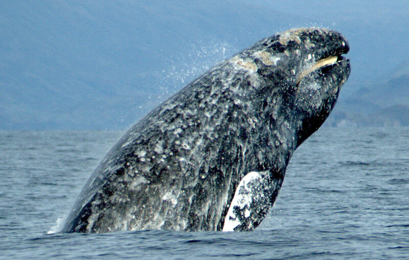
Are we really about to talk to whales?
The past decade has seen an explosion of new research into some of the most fascinating sounds in the sea: the vocalizations of whales and…
phys.org/news/2024-05-black-teachers-lost-civil-ri…

How Black teachers lost when civil rights won in Brown v. Board
Brown v. Board of Education, the Supreme Court decision that desegregated public schools, stands in the collective national memory as a turning point in America's…
phys.org/news/2024-05-cancer-drug-pollution-global…

Cancer drug pollution is a growing global concern
As incidence of cancer increases globally, the use of cancer drugs is also growing at a rate of approximately 10 percent per year in developed…
phys.org/news/2024-05-summer-northern-hemisphere-h…
Summer 2023 was northern hemisphere's hottest for 2,000 years, tree rings show
The summer of 2023 was the warmest in the non-tropical areas of the northern hemisphere for 2,000 years, a new study has shown.
phys.org/news/2024-05-blooded-dinosaurs-roamed-ear…

When the first warm-blooded dinosaurs roamed Earth
Scientists once thought of dinosaurs as sluggish, cold-blooded creatures. Then research suggested that some could control their body temperature, but when and how that shift…
phys.org/news/2024-05-pyramids-built-lost-river-sc…

Pyramids built along long-lost river, scientists discover
Scientists have discovered a long-buried branch of the Nile river that once flowed alongside more than 30 pyramids in Egypt, potentially solving the mystery of…
phys.org/news/2024-05-danger-beauty-solar-storms.h…

'Danger behind the beauty': More solar storms could be heading our way
Tourists normally have to pay big money and brave cold climates for a chance to see an aurora, but last weekend many people around the…
techxplore.com/news/2024-05-terminal-diode-wireles…
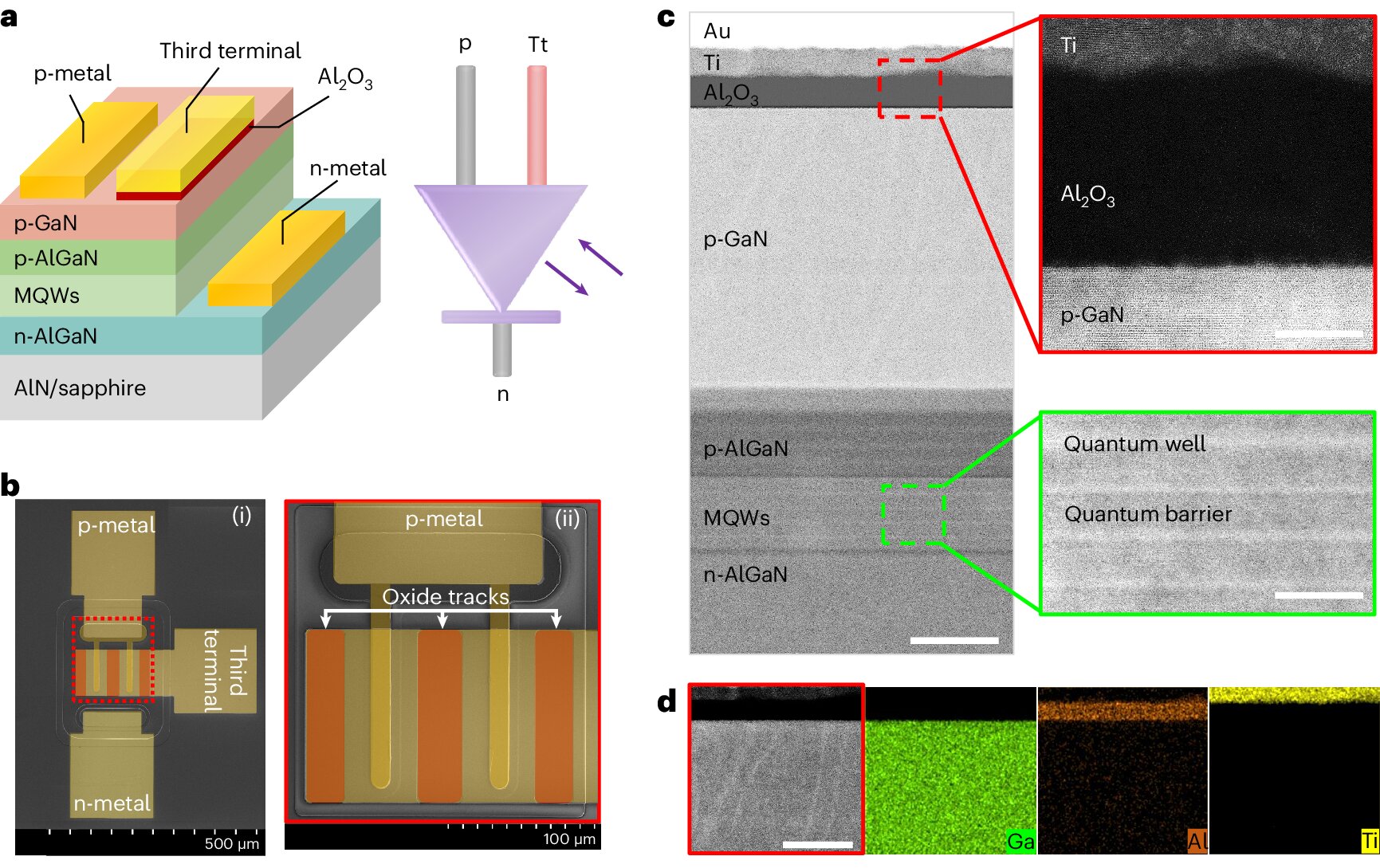
A promising three-terminal diode for wireless communication and optically driven computing
Two-terminal devices are electronic components connected to electrical circuits via two electrical terminals. Although these components are the key building blocks of most existing devices,…
medicalxpress.com/news/2024-05-covid-vaccinations-…

Repeat COVID-19 vaccinations elicit antibodies that neutralize variants, other viruses
The COVID-19 pandemic is over, but the virus that caused it is still here, sending thousands of people to the hospital each week and spinning…
Latest Stories


Electronic Frontier Foundation
- The Alaska Supreme Court Takes Aerial Surveillance’s Threat to Privacy Seriously, Other Courts Should Too May 29, 2024
- Don't Let the Sun Go Down on Section 230 | EFFector 36.7 May 29, 2024
- A Wider View on TunnelVision and VPN Advice May 29, 2024
- EFF Submission to the Oversight Board on Posts That Include “From the River to the Sea” May 28, 2024
The Intercept
- Joe Biden’s Terrible Israel Policy Is Really About Getting in Bed With Saudi Arabia May 30, 2024
- Leonard Leo Built the Conservative Court. Now He’s Funneling Dark Money Into Law Schools. May 29, 2024
- Sterilization, Murders, Suicides: Bans Haven’t Slowed Abortions, and They’re Costing Lives May 26, 2024
- The Media Still Doesn’t Grasp the Danger of Trump May 25, 2024
VTDigger
- Mike Fisher: Thank you, legislators, for listening to Vermonters’ voices and improving Medicare affordability May 30, 2024
- Ed Baker: Supporting overdose prevention centers is a moral imperative May 30, 2024
- Putney fire services return after turmoil, two-month hiatus May 30, 2024
- Vermont Conversation: Are the kids all right? Vermont high school students speak out May 29, 2024
