
Iceland Volcano: The Eruption Is Focused On Five Vents -- Iceland Met Office
Categories
Edited | All Content | Disasters | Environment | Earthquakes | Volcanos | Government | Science | North America | Europe | Atlantic Ocean
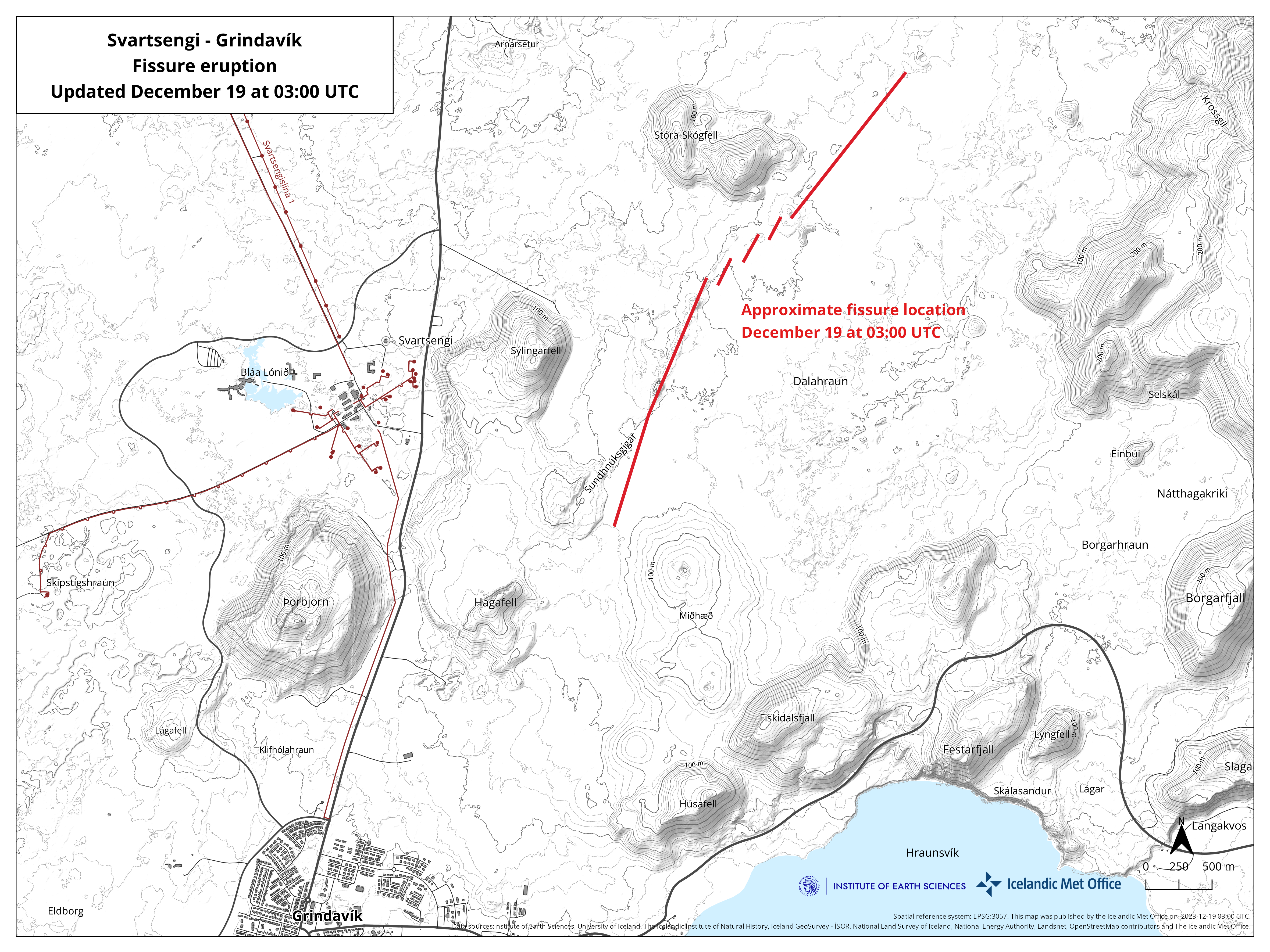
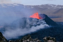
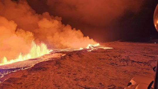 The eruptive fissure is about 4 km long, with the northern end just east of Stóra-Skógfell and the southern end just east of Sundhnúk. The distance from the southern end to the edge of Grindavík is almost 3 km. Photo: Iceland Met Office
The eruption is located about 4 km northeast of Grindavik
Little activity at the southern end of the fissure
Information updated regularly here and on X (Formerly known as Twitter).
Updated 19 December at 18:30 UTC
The eruption continues to weaken. New aerial images of the area show that there are now three vents erupting southeast of Stóra-Skógfell, down from the previous five. The lava has mostly flowed east from the eruption site, but there is also a lava tongue flowing west from the region north of Stóra-Skógfell.
Since the eruption began, about 320 earthquakes have been measured over the magma channels. The largest earthquake, with a magnitude of 4.1, occurred at 23:25 on Monday. After midnight, seismic activity significantly decreased, and since 12:00 today, only 10 earthquakes have been recorded in the region. Following the eruption at Sundhnúksgíga, the land in Svartsengi subsided more than 5 cm. Previously, the land had risen there by about 35 cm since the formation of the magma channel on November 10. It is too early to determine if magma will continue to accumulate under Svartsengi and whether the land will start to rise again.
While the eruption continues at Sundhnúksgíga, there is an increased likelihood that more vents may open along the original fissure as well as further north or south. Looking back at the lead-up to the eruption reveals that there were approximately 90 minutes between the first indicators and the start of the eruption. Therefore, the warning time for new vent openings at Sundhnúk could be very short.
Updated 19 December at 14:30 UTC
The size of the volcanic eruption at Sundhnúksgígar continues to diminish. The lava flow is estimated to be about one-quarter of what it was at the beginning of the eruption on 18 December, and a third of the original fissure is active. The lava fountains are also lower than at the start of the eruption, reaching about 30 meters at their highest. These figures are based on visual estimates from a reconnaissance flight early on 19 December.
The development of the eruption is similar to recent eruptions at Fagradalsfjall, where the fissures are starting to contract and form individual eruption vents. Presently, there are about five eruption vents spread along the original fissure.
According to information from scientists who went on a second helicopter flight with the Icelandic Coast Guard at around 04:00 UTC today, the total length of the fissure eruption has not changed much from the beginning. There was little activity at the southern end of the fissure near Hagafell, and the majority of the lava flow is heading east towards Fagradalsfjall. Two streams reach west, both north of Stóra-Skógfell.
At the time of publication, the volcanic plume is drifting from the west and northwest. Gas pollution might be noticeable in Vestmannaeyjar today, but not elsewhere in populated areas. According to the weather forecast, gas pollution might be detected in the capital area late tonight or tomorrow morning.
A new hazard assessment map is being prepared, and it will be published later today.
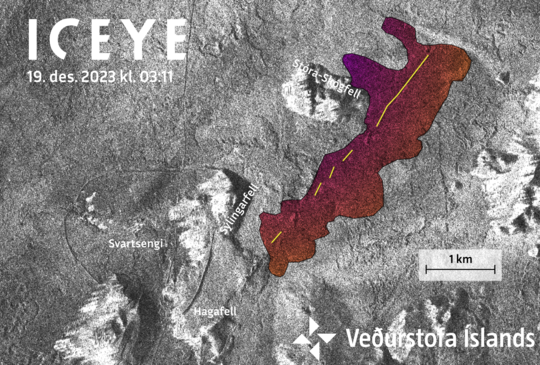 Amplitude image from an ICEYE satellite acquired at 03:11 this morning (19 Dec. 2023). Preliminary analysis of this image shows the new eruptive fissure (yellow line) and lava flow (colored area). Notice that the dams built around Svartsengi are clearly visible.
Updated 19 December at 3:00
The intensity of the volcanic eruption, which started about four hours ago, is decreasing. This is evident from seismic and GPS measurements. The fact that the activity is decreasing already is not an indication of how long the eruption will last, but rather that the eruption is reaching a state of equilibrium. This development has been observed at the beginning of all eruptions on the Reykjanes Peninsula in recent years.
The eruptive fissure is about 4 km long, with the northern end just east of Stóra-Skógfell and the southern end just east of Sundhnúk. The distance from the southern end to the edge of Grindavík is almost 3 km.
The Icelandic Meteorological Office continues to monitor the activity and is in direct contact with civil protection and response units in the area. A meeting of scientists will be held tomorrow morning to evaluate the overnight development of the eruption.
Updated 19 December at 02:10
According to the latest aerial observations and seismicity, the eruption fissure is expanding to the south. At the time of publication, the southern end of the fissure was close to Sundhnúkur.
The eruption is located on the dyke intrusion that formed in November. The rate of lava discharge during the first two hours of the eruption was thought to be on a scale of hundreds of cubic metres per second, with the largest lava fountains on the northern end of the fissures.
Lava is spreading laterally from either side of the newly opened fissures. From real-time GPS measurements, significant ground deformation has accompanied the opening of the eruption fissures.
Since midnight on 19 December, the level of seismicity at the eruption site has decreased. Additionally, estimates of fissure lengthening suggest that the eruption has decreased in intensity since its onset at 22:17 on 18 December.
Updated 18 December at 23:00
At 22:17 this evening, a volcanic eruption began north of Grindavík on the Reykjanes peninsula. The eruption is located close to Sundhnúkagígar, about four kilometres northeast of Grindavík, and it can be seen on nearby web cameras. The eruption was preceded by an earthquake swarm that started at 21:00.
A Coast Guard helicopter will take off shortly to confirm the exact location and size of the eruption.
Updated 16 December at 14:00 UTC
At this stage it is too early to say if magma accumulation at Svartsengi has stopped and the inflation is over. The rate of deformation has decreased somewhat in recent days, but more data is needed to interpret the possible development of the activity in Svartsengi.
Scientists will continue to analyze the data in the coming days.
A new hazard map will be released on Wednesday December 20th, which will reflect the interpretation of the latest data.
Updated 15. December at 13:00 UTC
Generally weak seismicity continues in the area affected by the dike and is mostly concentrated near Hagafell. Since Tuesday December 12, 460 earthquakes, 30 of which were greater than M1.0, have been measured. The largest earthquake in this time was M2.8 near Hagafell on Tuesday morning. Data from GPS stations and satellite images show that uplift due to the accumulation of magma continues around Svartsengi. While magma continues to accumulate in this area, further dikes or an eruption remain possible.
The hazard map published on December 6 Icelandic map here below continues to be valid until December 20. Conditions inside and outside the demarcated hazard zones can change with little warning.

Updated 13. December at 11:15 UTC
The area around Svartsengi continues to inflate. The rate of inflation has decreased somewhat since Friday, but it is still greater than it was prior to the formation of the dike that traveled under Grindavík November 10 .
While magma continues to accumulate around Svartsengi, further dikes or an eruption remain possible.
If another dike forms it is considered to be likeliest that it would follow the same path as the November 10 dike. The most likely location for a potential eruption under these conditions is assessed to be north of Grindavík in the direction of Hagafell and the area around Sundhnúkagígar.
Seismic activity continues at a similar level to the previous days. It is generally weak and mostly in the area around Hagafell.
Updated 6. December at 18:00 UTC
Latest geodetic modelling results suggests that the magma inflow to the dike that formed on November 10 has likely ceased. The chances of an eruption happening along the dike at this time have therefore significantly decreased. However, magma accumulation continues beneath Svartsengi.
The ongoing activity at Svartsengi, which began in October, is not yet over and a new chapter may have begun with an increased chance of a new magma propagation and, subsequently, increased likelihood of an eruption.
As previously mentioned, the dike beneath Grindavík was fed by magma accumulating beneath Svartsengi. It is likely that this sequence of events will repeat. When looking at the overall pattern with repeated magma accumulation, it can be estimated that the next magma propagation from Svartsengi might be on a smaller scale than the one previously formed on November 10. A magma propagation could persist for several hours or days with an increased risk due to seismic activity and deformation during that period.
Signs of a magma propagation include a sudden increase in seismic activity and rapid changes in ground deformation. These signs can be observed on instruments several hours before the magma propagation is likely to pose a threat to Svartsengi or Grindavík. If a magma propagation occurs, the Icelandic Meteorological Office will immediately activate response plans for public safety.
Following a magma propagation, the likelihood of an eruption increases. As mentioned above, it is most likely that magma will propagate from Svartsengi into the previously formed dike on November 10. Making it the most likely area for an eruption.
It is not possible to estimate when the next magma propagation will occur. The uncertainty is considerable, and a magma propagation could happen in the next few days or possibly after several months.
The Icelandic Meteorological Office continues to monitor the area closely and continues to monitor any signs of magma propagation and other changes that could pose further danger in the area near Svartsengi and Grindavík.
Comparison of Svartsengi and Krafla Fires
In the last week, approximately 300-500 earthquakes were detected in a 24-hour period around the dike intrusion. The largest earthquake was a M2.7 near Hagafell on Friday evening. Since midnight today, about 90 earthquakes have been detected along the dike, all measuring below a M2.0. The majority of seismic activity continues to be concentrated along the middle of the dike at about 3-4 km depth. Due to subsidence in Svartsengi the stress in the Earth's crust has changed. Until the previous stress level is reached, it can be expected that minor seismicity continuous in the region.
Despite the recent decrease in seismic activity in the last weeks, further unrest can be expected on the Reykjanes Peninsula. Examples of similar unrest can be seen in the Krafla Fires that began in 1975. Over a 10-year period, there were 20 magma propagations, with 9 of them resulting in an eruption (see explanatory image below). In the Krafla Fires, all of the magma propagations fed the same dike but they varied in size. A similar recurrence can also be observed in the activity around Fagradalsfjall.
The latest geodetic modeling results indicate that the volume of magma currently accumulated under Svartsengi is considerably less than the volume accumulated before the dike intrusion on November 10. When looking at the magma accumulation and magma propagation in the Krafla Fires, it is evident that the largest amount of magma had accumulated in the Krafla caldera before the first volcanic eruption. A smaller amount of magma accumulated in the caldera before the next magma propagation occurred. It can be estimated that a similar development will occur in relation to magma accumulation under Svartsengi, and a smaller amount of magma needs to accumulate before triggering the next magma propagation into the dike. It is likely that slowly increasing seismicity will be detected before a new magma propagation takes place, indicating increased pressure under Svartsengi.
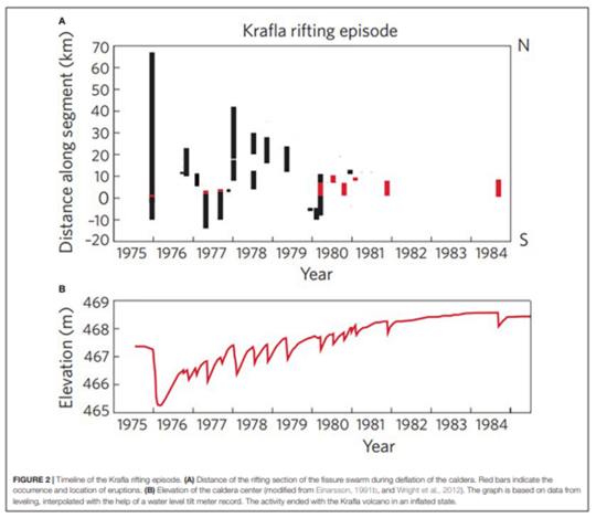
The image shows the interaction between the formation of dikes and uplift in the middle of the Krafla crater. The lower picture shows the elevation of land within the Krafla crater, while the upper shows the distance between Krafla crater and the unrest. (Páll Einarsson and Bryndís Brandsdóttir, 2021)
(more)
- CreatedTuesday, December 19, 2023
- Last modifiedThursday, December 21, 2023
SUBSCRIBE
Sign up for our weekly newsletter and World News Trust project updates.

World Desk Activities

cpj.org/resources-for-journalists-covering-protest…

cpj.org/2020/09/guide-to-legal-rights-in-the-u-s/

pressfreedomtracker.us/submit-incident/

drive.google.com/file/d/17XyVCVOTq59bvTEG_RZAQMgrF…

www.icfj.org/news/new-icfj-knight-fellows-work-sup…

U.S.Justice Department: "Radical Right vs. Radical Left: Terrorist Theory and Threat"
www.ojp.gov/ncjrs/virtual-library/abstracts/radica….
ijnet.org/en/story/tips-building-networks-reach-au…

trustingnews.org/how-trustworthy-is-your-newsroom-…

Latest Stories


Electronic Frontier Foundation
- EFF to Court: Electronic Ankle Monitoring Is Bad. Sharing That Data Is Even Worse. May 17, 2024
- EFF Urges Ninth Circuit to Hold Montana’s TikTok Ban Unconstitutional May 17, 2024
- Fair Use Still Protects Histories and Documentaries—Even Tiger King May 15, 2024
- The Cybertiger Strikes Again! EFF's 8th Annual Tech Trivia Night May 15, 2024
The Intercept
- The State Department Says Israel Isn’t Blocking Aid. Videos Show the Opposite. May 18, 2024
- Medical Workers Evacuated From Gaza, but 3 Americans Refuse to Leave May 17, 2024
- An Israeli Company Is Hawking Its Self-Launching Drone System to U.S. Police Departments May 17, 2024
- The Consumer Finance Protection Bureau Is Constitutional, After All May 16, 2024
