
Iceland Volcano: Continued Ground Uplift beneath Svartsengi -- Iceland Met Office
Categories
Edited | All Content | Disasters | Earthquakes | Volcanos | Government | Technology | North America | Europe | Atlantic Ocean | News -- WNT Original
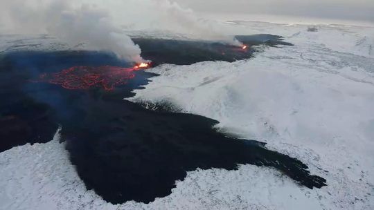 Photo taken on Dec. 19 at 15:00 and shows the three fountains, the most powerful being from two of them. At the front of the picture is the lava tongue that stretches to the west just north of Stóra-Scógfell. (Photo: National Police Chief's Special Squad)
The likelihood of the next eruption increases day by day
Information is updated regularly here and on X (Formerly known as Twitter).
Updated 27 December at 14:20 UTC
Since 22 December, around 730 earthquakes have been recorded in the vicinity of the magma intrusion, of which 40 had a magnitude above M1. The largest earthquake over this period had a magnitude of 2.1 on 26 December, north of Hagafell. Most of the earthquakes are occurring at a depth of 4 km. Additionally, between 22 December and today, around 140 earthquakes have been located on the western side of Fagradalsfjall. Five of these earthquakes were above M1 in size and the overall depth range was 4 to 7 km.
Ground deformation continues in the Svartsengi region, and the rate of deformation is now similar to before the eruption on 18 December 2023. This means that magma continues to accumulate under Svartsengi. Therefore, it is increasingly likely that another magma intrusion will occur, possibly leading to a second volcanic eruption. Geodetic modeling results indicate that over 10 million m3 of magma were sourced from beneath Svartsengi to feed the intrusion that formed on 18 December, which led to the eruption. Based on the ongoing uplift rate, it will take one to two weeks for the same amount of magma to accumulate again underneath Svartsengi. There is still significant uncertainty on when the built-up in magma pressure will be sufficient to trigger the next magma intrusion.
It should be noted that the original magma intrusion, which formed on 10 November, extended 15 km from Kálfafellsheiði in the north to the southwest of Grindavík, just offshore. This means that magma propagated at depth beneath the entire area, including the town of Grindavík. However, the most likely source area for the next eruption is between Stóra-Skógfell and Hagafell. Based on insights from the December 2023 eruption, the likelihood of the next event increases day by day.
The hazard assessment map issued on 22 December 2023 remains valid. Assuming an unchanged situation, a new map will be issued on 29 December.
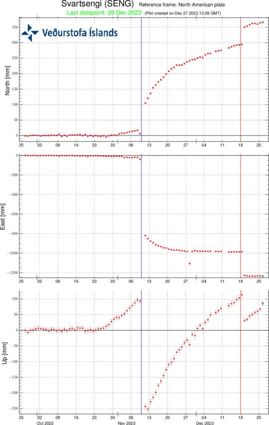 Time-series of continuous GPS solutions from station Svartsengi (SENG). The graph shows ground displacements in three components over the past 90 days. From bottom to top they are: up, east, and north, all measured in millimetres. The blue, vertical line shows the timing of the 10 November magma intrusion, and the red line the volcanic eruption on 18 December 2023. Each data point represents a 24-hour solution, and the vertical component shows clearly the ongoing ground uplift at Svartsengi.
(more)
- CreatedWednesday, December 27, 2023
- Last modifiedFriday, December 29, 2023
SUBSCRIBE
Sign up for our weekly newsletter and World News Trust project updates.

World Desk Activities

cpj.org/resources-for-journalists-covering-protest…

cpj.org/2020/09/guide-to-legal-rights-in-the-u-s/

pressfreedomtracker.us/submit-incident/

drive.google.com/file/d/17XyVCVOTq59bvTEG_RZAQMgrF…

www.icfj.org/news/new-icfj-knight-fellows-work-sup…

U.S.Justice Department: "Radical Right vs. Radical Left: Terrorist Theory and Threat"
www.ojp.gov/ncjrs/virtual-library/abstracts/radica….
ijnet.org/en/story/tips-building-networks-reach-au…

trustingnews.org/how-trustworthy-is-your-newsroom-…

Latest Stories


Electronic Frontier Foundation
- EFF to Court: Electronic Ankle Monitoring Is Bad. Sharing That Data Is Even Worse. May 17, 2024
- EFF Urges Ninth Circuit to Hold Montana’s TikTok Ban Unconstitutional May 17, 2024
- Fair Use Still Protects Histories and Documentaries—Even Tiger King May 15, 2024
- The Cybertiger Strikes Again! EFF's 8th Annual Tech Trivia Night May 15, 2024
The Intercept
- The State Department Says Israel Isn’t Blocking Aid. Videos Show the Opposite. May 18, 2024
- Medical Workers Evacuated From Gaza, but 3 Americans Refuse to Leave May 17, 2024
- An Israeli Company Is Hawking Its Self-Launching Drone System to U.S. Police Departments May 17, 2024
- The Consumer Finance Protection Bureau Is Constitutional, After All May 16, 2024
